Select Item below to DOWNLOAD - Once item is selected, right click and choose 'save as'
c160f3b367c94f6d8a8abcbe0d66f920
Master plan, Land Status Document sheet, p. 1
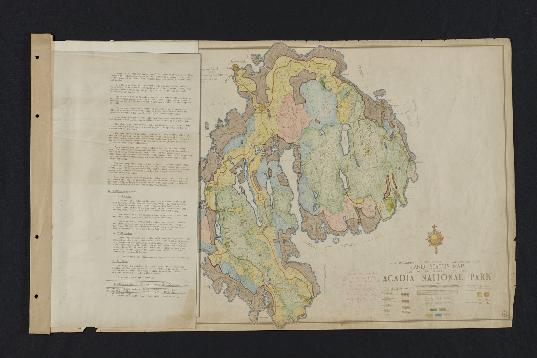
Document sheet attached to hand colored map of Mount Desert Island. Map is titled, "U.S. Department of the Interior National Park Service Land Status Map Part of the Master Plan for Acadia National Park". See entry, "U.S. Department of the Interior National Park Service Land Status Map Part of the Master Plan for Acadia National Park" for more information on the map. Document sheet describes the state and town road system on Mount Desert Island in relation to the Acadia National Park's road system. Includes details for the road system, parking lot, trail system, and buildings in the Cadillac summit Area. Building details include: location, use, type, cubage, year built, condition, and notes. Additional Cadillac Summit Area information on page 2. Locations mentioned include: Town of Bar Harbor, Hulls Cove, State Route 3, Bubble Pond, Beaver Dam Pool, Cadillac Mountain, Eagle Lake, Woodbury Park, Witch Hole Pond, Bear Brook Campground, NP-1 CCC Camp, Park Headquarters, Sieur de Monts Spring Area, Kebo Valley, Cadillac Summit Tavern concession. ; Plan Number: NPAca2695
CollectionNbr: 4000 ; SeriesNbr: 012.002.001 ;
U. S. National Park Service
Permission must be secured from the individual copyright owners to reproduce any copyrighted materials contained within this website.
Restrictions apply on use and/or reproduction
Image
Acadia National Park, Code: ACAD
Old Farm, Mount Desert Island, Bar Harbor, Cadillac Mountain, Eagle Lake, Sieur de Monts
Acadia National Park, Maine
Latitude: 44.3593788146973, Longitude: -68.2397308349609
Acadia National Park, Maine
Latitude: 44.3593788146973, Longitude: -68.2397308349609
1940s
01/01/1940 - 12/30/1949
Paper ; Physical Characteristics: Good/Fair - Hand colored, script, and typed text. Moderate/severe tears and creases. ; Extent: 1 Each
HQ/R5/U2/S3, HQ/R7, HQ/R8
Public Can View
Person: Curator
Organization: US National Park Service
Address: Acadia National Park, Bar Harbor ME
Email: Acadia_Collections@nps.gov
Organization: US National Park Service
Address: Acadia National Park, Bar Harbor ME
Email: Acadia_Collections@nps.gov
Wednesday, October 17, 2018 8:04:43 AM
Wednesday, October 17, 2018 8:04:43 AM
Master Plan, Land Status Map & Doc Pg 1.tif
tif
216.9 MB
Historic