Select Item below to DOWNLOAD - Once item is selected, right click and choose 'save as'
34507462fea14b39b15de34e5b4bc719
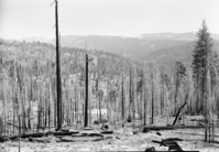
View of Cherry Valley from approach road shwooing gap in which dam will be constructed by City of San Francisco.
View of Cherry Valley from approach road shwooing gap in which dam will be constructed by City of San Francisco.
View of Cherry Valley from approach road shwooing gap in which dam will be constructed by City of San Francisco.
Negative Number: D_2533
U. S. National Park Service
Permission must be secured from the individual copyright owners to reproduce any copyrighted materials contained within this website.
Public domain
Image
Yosemite National Park, Code: YOSE
Yosemite National Park, California
Latitude: 37.8399200439453, Longitude: -119.540397644043
Latitude: 37.8399200439453, Longitude: -119.540397644043
August 1950
08/01/1950 - 08/30/1950
YOSE: Box 24
Public Can View
Person: Archivist
Organization: US National Park Service
Address: Yosemite National Park Archives, PO Box 700-W, El Portal, CA 95318
Email: yose_archives@nps.gov
Organization: US National Park Service
Address: Yosemite National Park Archives, PO Box 700-W, El Portal, CA 95318
Email: yose_archives@nps.gov
Tuesday, August 14, 2018 12:07:27 PM
Tuesday, August 14, 2018 12:07:27 PM
D_2533.tif
tif
27.7 MB
Museum
Cherry Valley area west of Lake Eleanor; (taken to record area before extensive reservoir development)
Cherry Valley area west of Lake Eleanor; (taken to record area before extensive reservoir development)
Cherry Valley area west of Lake Eleanor; (taken to record area before extensive reservoir development)
Cherry Valley area west of Lake Eleanor; (taken to record area before extensive reservoir development)
Cherry Valley area west of Lake Eleanor; (taken to record area before extensive reservoir development)