Select Item below to DOWNLOAD - Once item is selected, right click and choose 'save as'
b34e65f2-35c6-4c72-91b5-077963a4b2dc
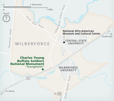
Park Map - Charles Young Buffalo Soldiers National Monument
Map of Charles Young Buffalo Soldiers National Monument (NM) in Wilberforce, Ohio. The long edge of the trapezoidal-shaped town is angled to the northeast. The town is shown in beige, surrounding areas in blue, and the park represented with a green square.
Screen-viewable file; Adobe print production files can be downloaded from the Compressed zip Version link
Map Projection: WM; Map Type: park map
U.S. National Park Service
The National Park Service maps are government produced and are in the public domain. Anyone may, without restriction under U.S. copyright laws: Reproduce the work in print or digital form; Create derivative works; Perform the work publicly; Display the work; Distribute copies or digitally transfer the work to the public by sale or other transfer of ownership, or by rental, lease, or lending. Please note, a user who modifies and/or republishes National Park Service maps are responsible for any problems encountered with the maps, due to their change or modification.
Public domain
Document
Charles Young Buffalo Soldiers National Monument, Code: CHYO
Charles Young Buffalo Soldiers National Monument, Greene County, Ohio
Latitude: 39.7071762084961, Longitude: -83.8903121948242
Latitude: 39.7071762084961, Longitude: -83.8903121948242
2020-04-06
Public Can View
Person: Harpers Ferry Center
Organization: US National Park Service
Address: Harpers Ferry Center, Harpers Ferry, WV
Email: HFC_Cartography@nps.gov
Organization: US National Park Service
Address: Harpers Ferry Center, Harpers Ferry, WV
Email: HFC_Cartography@nps.gov
Monday, April 25, 2022 4:39:46 PM
Friday, September 26, 2025 11:34:37 PM
CHYOmap1.pdf
pdf
1.9 MB
Map