Select Item below to DOWNLOAD - Once item is selected, right click and choose 'save as'
49b93926-1009-4f45-8ef9-e357296001d3
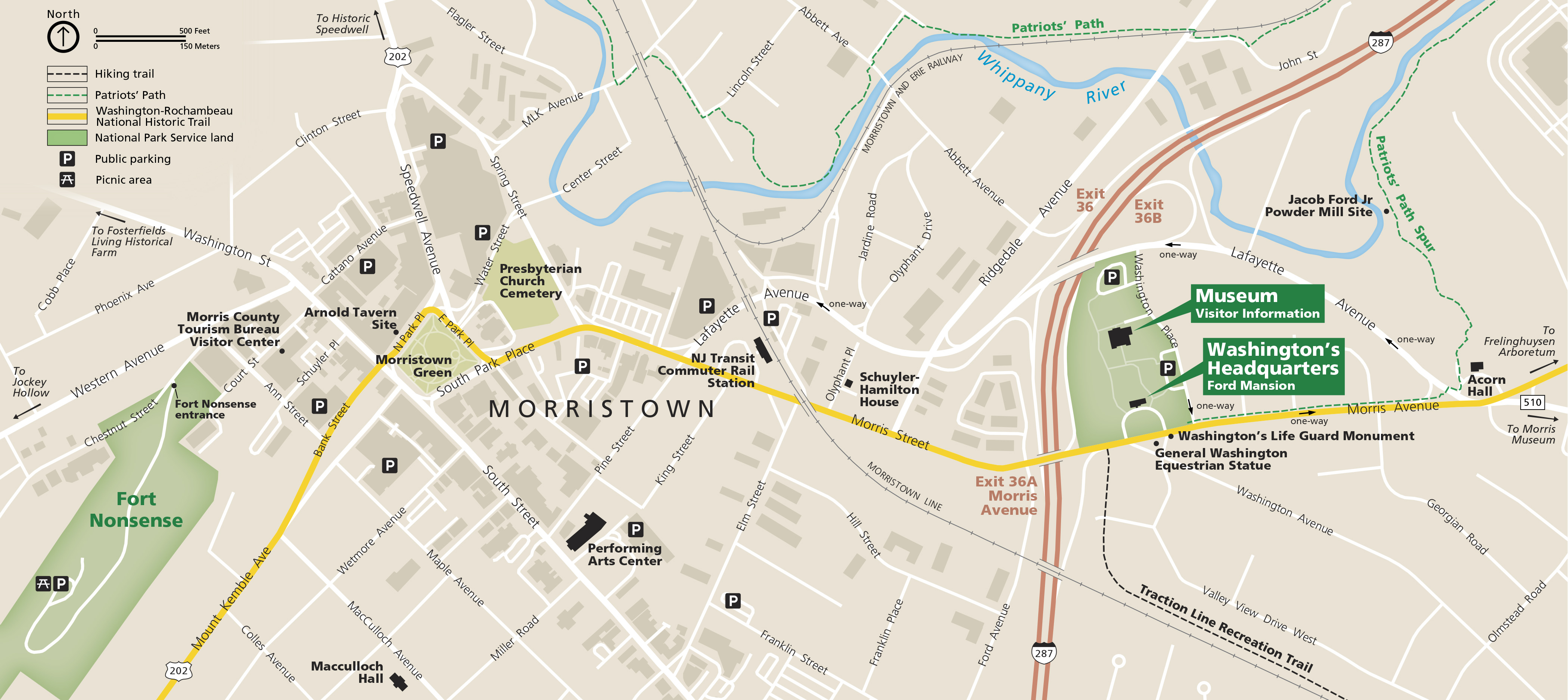
Morristown Downtown Map - Morristown National Historical Park
Map of downtown Morristown and the Morristown National Historical Park in New Jersey. The map is mostly beige with white solid lines denoting roads and streets. Two areas of National Park Service land are highlighted in green on the left and right sides of the map. The Washington-Rochambeau National Historic Trail is shown as a yellow line.
Screen-viewable file; Adobe print production files can be downloaded from the Compressed zip Version link
Map Projection: Other; Map Type: unassigned
U.S. National Park Service
The National Park Service maps are government produced and are in the public domain. Anyone may, without restriction under U.S. copyright laws: Reproduce the work in print or digital form; Create derivative works; Perform the work publicly; Display the work; Distribute copies or digitally transfer the work to the public by sale or other transfer of ownership, or by rental, lease, or lending. Please note, a user who modifies and/or republishes National Park Service maps are responsible for any problems encountered with the maps, due to their change or modification.
Public domain
Document
Morristown National Historical Park, Code: MORR
Morristown National Historical Park, New Jersey
Latitude: 40.7692718505859, Longitude: -74.5282669067383
Latitude: 40.7692718505859, Longitude: -74.5282669067383
2018-06-19
Public Can View
Person: Harpers Ferry Center
Organization: US National Park Service
Address: Harpers Ferry Center, Harpers Ferry, WV
Email: HFC_Cartography@nps.gov
Organization: US National Park Service
Address: Harpers Ferry Center, Harpers Ferry, WV
Email: HFC_Cartography@nps.gov
Wednesday, April 27, 2022 8:16:16 PM
Friday, September 26, 2025 11:36:42 PM
MORRmap2.pdf
pdf
10.6 MB
Map