NPS Museum Accession Number : ZION-00768
Zion Legacy HPC Database Number : HPC-008871
Organization: Zion National Park
Position: Museum Curator
Address: Zion National Park, State Route 9, Springdale, UT 84767
Email: zion_museum@nps.gov
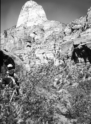
Beatty point in Kolob section. From near three forks of Taylor Creek; Larry Quist in foreground. ; ZION Museum and Archives Image 10022 ; ZION 10022
Beatty point in Kolob section. From near three forks of Taylor Creek; Larry Quist in foreground. ; ZION Museum and Archives Image 10023 ; ZION 10023
Aerial view of Kolob at northwest corner of Zion National Park. Note snow on the tops of the mountains in early May. ; ZION Museum and Archives Image 10041 ; ZION 10041
View from Death Point. ; ZION Museum and Archives Image 10049 ; ZION 10049
View from Death Point. ; ZION Museum and Archives Image 10051 ; ZION 10051
42WS0069. Indian cave in Cave Valley, for the documenting pot hunter activities. Larry Florea in background. ; ZION Museum and Archives Image 10612 ; ZION 10612
42WS0069. Indian cave in Cave Valley to document pot hunter activities. ; ZION Museum and Archives Image 10613 ; ZION 10613
42WS0069. Indian cave in Cave Valley for documenting pot hunter activities and vandalism. ; ZION Museum and Archives Image 10615 ; ZION 10615
42WS0069. Indian cave in Cave Valley for documenting pot hunter activities and vandalism. ; ZION Museum and Archives Image 10617 ; ZION 10617
Man standing in La Verkin Creek canyon. ; ZION Museum and Archives Image 13422 ; ZION 13422
42WS0069. Indian cave in Cave Valley for documenting pot hunter activities and vandalism. ; ZION Museum and Archives Image 14853 ; ZION 14853
42WS0069. Indian cave in Cave Valley for documenting pot hunter activities and vandalism. ; ZION Museum and Archives Image 14855 ; ZION 14855
Kolob peaks looking west of Highway 91 (I-15) on road to new harmony toward peaks. Fender in foreground of frame. ; ZION Museum and Archives Image 7134 ; ZION 7134
Kolob peaks, view from the New Harmony road which is west of highway 91 (I-15). Headlight and fender in foreground of frame. ; ZION Museum and Archives Image 7135 ; ZION 7135
Paria Point and Beatty Point, south fork of Dry Creek. ; ZION Museum and Archives Image 7154 ; ZION 7154
Tucupit Point, Paria Point and Beatty Point. Middle (left) and south forks of Dry Creek. North Fork Timber Creek (upper right). ; ZION Museum and Archives Image 7155 ; ZION 7155
Tucupit Point, Paria Point and Beatty Point. Middle (left) and south forks of Dry Creek. North Fork Timber Creek (upper right). ; ZION Museum and Archives Image 7156 ; ZION 7156
La Verkin Creek with Navajo sandstone cliffs to either side. ; ZION Museum and Archives Image 7173 ; ZION 7173
Taylor Creek with massive Navajo sandstone wall above drainage. ; ZION Museum and Archives Image 7185 ; ZION 7185
Taylor Creek with Navajo sandstone cliffs above drainage. ; ZION Museum and Archives Image 7187 ; ZION 7187
Big Cave in La Verkin Creek canyon, with horse in foreground. ; ZION Museum and Archives Image 7193 ; ZION 7193
Timber Creek (Timber Top) with Navajo sandstone cliffs at head of drainage. ; ZION Museum and Archives Image 7198 ; ZION 7198
Horse Ranch Mountain. ; ZION Museum and Archives Image 7202 ; ZION 7202
Paria Point, framed by ponderosas. ; ZION Museum and Archives Image 7204 ; ZION 7204
Paria Point. ; ZION Museum and Archives Image 7205 ; ZION 7205
View from Death Point. ; ZION Museum and Archives Image 9909 ; ZION 9909
View from Spendlove Knoll looking east, Guardian Angels near south east corner of Kolob section. ; ZION Museum and Archives Image 9919 ; ZION 9919
View from Spendlove Knoll looking southeast down Lee Valley, private holdings in park, West Temple in distance. ; ZION Museum and Archives Image 9920 ; ZION 9920
View from Lee's Pass. ; ZION Museum and Archives Image 9952 ; ZION 9952
View from west of Lee's Pass toward finger canyons of the Kolob. Taken on high point south of Taylor Creek. ; ZION Museum and Archives Image 9963 ; ZION 9963