Select Item below to DOWNLOAD - Once item is selected, right click and choose 'save as'
f3929cdd-70f8-46b2-8cb6-1da67bdddae1
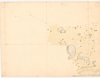
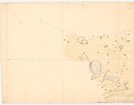
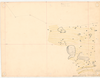
Sunset Point - Mariposa Grove
Sunset Point - Mariposa Grove
Hand-drawn topographic map of Sunset Point and Mariposa Grove
Item Number: YOSEAR001481, AlternateId: 02-A-087.02, Sheet 2/4, 0-15, 104/60110
Contact Yosemite National Park for more copyright information and use
Public domain:This digital asset is in the public domain. When using this asset for any purpose, including online, credit:'Courtesy U.S. National Parks'
104/60110, (YOSE TIC Number)
Image
Yosemite National Park, Code: YOSE
Yosemite National Park, California
Yosemite National Park, California
Latitude: 37.8399200439453, Longitude: -119.540397644043
Yosemite National Park, California
Latitude: 37.8399200439453, Longitude: -119.540397644043
nd
nd
Type:canvas, Dimensions: 18 x 24, Condition: good
YOSE Location: E4 DR5 F3
Public Can View
Person: Archivist
Organization: US National Park Service
Address: Yosemite National Park Archives, PO Box 700-W, El Portal, CA 95318
Email: yose_archives@nps.gov
Organization: US National Park Service
Address: Yosemite National Park Archives, PO Box 700-W, El Portal, CA 95318
Email: yose_archives@nps.gov
Monday, August 7, 2023 3:09:45 PM
Monday, August 7, 2023 3:09:45 PM
YOSEAR001481.tif
tif
484.2 MB
Historic
,
Map