Select Item below to DOWNLOAD - Once item is selected, right click and choose 'save as'
b35452d2-6be9-4883-9988-3d6092b4cd4b
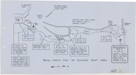
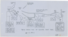
Rough Sketch Map of Glacier Point Area
Rough Sketch Map of Glacier Point Area
Page 9 of Glacier Point Area Sketch, including Site A-E, existing trail and estension of rim trail
Item Number: YOSEAR001829, AlternateId: 1001-009.02-F044
Contact Yosemite National Park for more copyright information and use
Public domain:This digital asset is in the public domain. When using this asset for any purpose, including online, credit:'Courtesy U.S. National Parks'
Image
Yosemite National Park, Code: YOSE
Yosemite National Park, California
Yosemite National Park, California
Latitude: 37.8399200439453, Longitude: -119.540397644043
Yosemite National Park, California
Latitude: 37.8399200439453, Longitude: -119.540397644043
nd
nd
Type:plasticized linen, Dimensions: 10.5 x 19, Condition: good
YOSE Location: D6 DR6 F4
Public Can View
Person: Archivist
Organization: US National Park Service
Address: Yosemite National Park Archives, PO Box 700-W, El Portal, CA 95318
Email: yose_archives@nps.gov
Organization: US National Park Service
Address: Yosemite National Park Archives, PO Box 700-W, El Portal, CA 95318
Email: yose_archives@nps.gov
Wednesday, August 2, 2023 11:35:27 PM
Wednesday, August 2, 2023 11:35:27 PM
YOSEAR001829.tif
tif
221.1 MB
Historic
,
Map