Select Item below to DOWNLOAD - Once item is selected, right click and choose 'save as'
a636a741-dd20-4f5d-ae83-352d34dc54e2
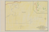
Mariposa Grove Area and Wawona Point Parking Area: Part of the Master Plan for the Yosemite National Park
Mariposa Grove Area and Wawona Point Parking Area: Part of the Master Plan for the Yosemite National Park
Aerial view map of the Mariposa Grove Area and proposed development
Item Number: YOSEAR001152, AlternateId: 01-A-001.60, Sheet #24, NP-YOS-2104-B
Contact Yosemite National Park for more copyright information and use
Public domain:This digital asset is in the public domain. When using this asset for any purpose, including online, credit:'Courtesy U.S. National Parks'
Image
Yosemite National Park, Code: YOSE
Yosemite National Park, California
Yosemite National Park, California
Latitude: 37.8399200439453, Longitude: -119.540397644043
Yosemite National Park, California
Latitude: 37.8399200439453, Longitude: -119.540397644043
1942
01/01/1942 - 12/30/1942
Type:paper, Dimensions: 27 x 41, Condition: good
YOSE Location: E4 DR1 F2
Public Can View
Person: Archivist
Organization: US National Park Service
Address: Yosemite National Park Archives, PO Box 700-W, El Portal, CA 95318
Email: yose_archives@nps.gov
Organization: US National Park Service
Address: Yosemite National Park Archives, PO Box 700-W, El Portal, CA 95318
Email: yose_archives@nps.gov
Monday, August 7, 2023 11:49:54 PM
Monday, August 7, 2023 11:49:54 PM
YOSEAR001152.tif
tif
307.5 MB
Historic
,
Map