Select Item below to DOWNLOAD - Once item is selected, right click and choose 'save as'
89955348-e505-4188-b41f-48819f2a59d5
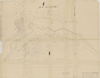
Map of Section 35 Showing Subdivisions & Ownerships
Map of Section 35 Showing Subdivisions & Ownerships
Map showing private land parcels in Wawona area
Item Number YOSEMCA0516, Scan Number: YOSE_MCA_-0005
Contact Yosemite National Park for more copyright information and use
Restrictions apply on use and/or reproduction
104/8074, (YOSE TIC Number)
Image
Yosemite National Park, Code: YOSE
Yosemite National Park, California
Yosemite National Park, California
Latitude: 37.8399200439453, Longitude: -119.540397644043
Yosemite National Park, California
Latitude: 37.8399200439453, Longitude: -119.540397644043
1941/02/15
02/15/1941
Type: Paper, Dimensions: 42 x 33
Public Can View
Person: Archivist
Organization: US National Park Service
Address: Yosemite National Park Archives, PO Box 700-W, El Portal, CA 95318
Email: yose_archives@nps.gov
Organization: US National Park Service
Address: Yosemite National Park Archives, PO Box 700-W, El Portal, CA 95318
Email: yose_archives@nps.gov
Tuesday, April 8, 2025 10:46:21 PM
Tuesday, April 8, 2025 10:46:21 PM
YOSEMCA0516sm.jpg
jpg
17.2 MB
Events
,
Map