Select Item below to DOWNLOAD - Once item is selected, right click and choose 'save as'
7d914f11-6628-4432-8f98-5ba6e8eeccd4
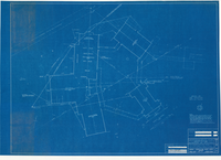
Yosemite Lodge 1955 - Location and Utility Plan Showing Proposed Alignment of Utilities
Yosemite Lodge 1955 - Location and Utility Plan Showing Proposed Alignment of Utilities
Architectural blueprints showing planned renovations of Yosemite Lodge including site plan showing sewer, water, and electric services, job no. 5514, sheet 1
Item Number YOSEMCA1130_01, Scan Number: YOSE_MCA_-0030
Contact Yosemite National Park for more copyright information and use
Restrictions apply on use and/or reproduction
Image
Yosemite National Park, Code: YOSE
Yosemite National Park, California
Yosemite National Park, California
Latitude: 37.8399200439453, Longitude: -119.540397644043
Yosemite National Park, California
Latitude: 37.8399200439453, Longitude: -119.540397644043
1955/11/25
11/25/1955
Type: Blueprint, Dimensions: 46 x 28
Public Can View
Person: Archivist
Organization: US National Park Service
Address: Yosemite National Park Archives, PO Box 700-W, El Portal, CA 95318
Email: yose_archives@nps.gov
Organization: US National Park Service
Address: Yosemite National Park Archives, PO Box 700-W, El Portal, CA 95318
Email: yose_archives@nps.gov
Tuesday, April 8, 2025 6:48:12 PM
Tuesday, April 8, 2025 6:48:12 PM
YOSEMCA1130_01.tif
tif
1262.7 MB
Historic