Select Item below to DOWNLOAD - Once item is selected, right click and choose 'save as'
594f5345-524f-434b-2022-020241226011
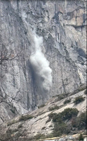
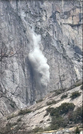
Upper Yosemite Falls Trail rock fall
A rock fall came from high on the Forbidden Wall, damaging over 20 switchbacks of the Upper Yosemite Falls Trail, injuring one person, and temporarily stranding 14 hikers above that section of trail. An exfoliation slab approximately 9 m tall, 2.5 m wide, and 1.5 m thick detached and tumbled down a series of joint-controlled ledges creating a dust cloud, then free-fell approximately 230 meters to the base of the cliff.
UTM East: 270649; UTM North: 4181814; Elevation: 2104
U.S. National Park Service
To the best of our knowledge we believe this image to be copyright free and in the public domain. When using this asset for any purpose, including online, credit: 'Courtesy U.S. National Parks'
Georgina Royse / NPS
Public domain
image
Yosemite National Park, Code: YOSE
Yosemite Falls
Latitude: 37.7549101616307, Longitude: -119.603410082157
Upper Yosemite Falls Trail
Yosemite National Park, California
Latitude: 37.8399200439453, Longitude: -119.540397644043
Latitude: 37.7549101616307, Longitude: -119.603410082157
Upper Yosemite Falls Trail
Yosemite National Park, California
Latitude: 37.8399200439453, Longitude: -119.540397644043
2024/12/26
12/26/2024
Public Can View
Person: Greg Stock
Organization: Yosemite NP
Position: Park Geologist
Address: El Portal, CA 95318
Email: greg_stock@nps.gov
Organization: Yosemite NP
Position: Park Geologist
Address: El Portal, CA 95318
Email: greg_stock@nps.gov
Tuesday, February 25, 2025 6:34:06 PM
Tuesday, February 25, 2025 6:34:06 PM
2024122601_2_Georgina_Royse.jpg
jpg
418.9 kB
Events