Select Item below to DOWNLOAD - Once item is selected, right click and choose 'save as'
594f5345524f434b2022020110325022
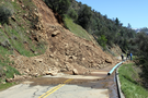
2011 Foresta Road debris slide
A debris slide from a steep slope above forms a cone of rock and soil material that is covering both lanes of a road. Three people stand by the slide observing.
A debris slide occurred onto Foresta Road between Rancheria and El Portal, just west of the El Portal wood lot. The slide initiated from a tall road cut and consisted of soil and angular metamorphic clasts on top of weathered granitic bedrock. The cone of slide material covered both lanes of Foresta Road, up to 6-7 m deep on the northern (westbound) lane.
UTM East: 253284; UTM North: 4173318; Elevation: 580
U.S. National Park Service
To the best of our knowledge we believe this image to be copyright free and in the public domain. When using this asset for any purpose, including online, credit: 'Courtesy U.S. National Parks'
NPS Photographer
Public domain
image
Yosemite National Park, Code: YOSE
Merced River Gorge
Latitude: 37.6739071879284, Longitude: -119.79743597
El Portal Road
Foresta Road
Yosemite National Park, California
Latitude: 37.8399200439453, Longitude: -119.540397644043
Latitude: 37.6739071879284, Longitude: -119.79743597
El Portal Road
Foresta Road
Yosemite National Park, California
Latitude: 37.8399200439453, Longitude: -119.540397644043
20110328
03/25/2011
Public Can View
Organization: Yosemite NP
Position: Park Geologist
Address: El Portal, CA 95318
Email: greg_stock@nps.gov
Position: Park Geologist
Address: El Portal, CA 95318
Email: greg_stock@nps.gov
Wednesday, May 11, 2022 11:57:28 PM
Tuesday, August 9, 2022 5:36:21 PM
2011032502_2_NPS.jpg
jpg
11.9 MB
Events