Select Item below to DOWNLOAD - Once item is selected, right click and choose 'save as'
12493c04-723f-4cdb-9004-b6cae96ad9f6
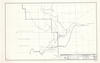
Location of Foresta: S2&3 T3S R20E MDB & M
Location of Foresta: S2&3 T3S R20E MDB & M
Map of boarder between Yosemite National Park and Stanislaus National Forest
Item Number: YOSEAR001888, AlternateId: Sheet 1 of 1, 104/60071
Contact Yosemite National Park for more copyright information and use
Public domain:This digital asset is in the public domain. When using this asset for any purpose, including online, credit:'Courtesy U.S. National Parks'
104/60071, (YOSE TIC Number)
Image
Yosemite National Park, Code: YOSE
Yosemite National Park, California
Yosemite National Park, California
Latitude: 37.8399200439453, Longitude: -119.540397644043
Yosemite National Park, California
Latitude: 37.8399200439453, Longitude: -119.540397644043
1963
01/01/1963 - 12/30/1963
Type:tracing paper, Dimensions: 24 x 38, Condition: good
YOSE Location: E3 DR10 F24
Public Can View
Person: Archivist
Organization: US National Park Service
Address: Yosemite National Park Archives, PO Box 700-W, El Portal, CA 95318
Email: yose_archives@nps.gov
Organization: US National Park Service
Address: Yosemite National Park Archives, PO Box 700-W, El Portal, CA 95318
Email: yose_archives@nps.gov
Wednesday, August 2, 2023 10:30:17 PM
Wednesday, August 2, 2023 10:30:17 PM
YOSEAR001888.tif
tif
481.9 MB
Historic
,
Map