Select Item below to DOWNLOAD - Once item is selected, right click and choose 'save as'
9ee6ed7e58e54ee595ac53542070c977
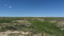
Ruts and swales with a marker, at Comanche National Grassland
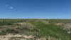
A grassy field with a swale in the distance and a blue sky in the background.
A limestone marker sits beside ruts and swales in the Comanche National Grassland; It was an important water supply on the trail and a stage station; it was also the scene of several Indian attacks. Trail ruts are still visible near the spring; a few building remains are nearby; General Location- 37.69363632; -103.912924; 4775 feet
U.S. National Park Service
Permission must be secured from the individual copyright owners to reproduce any copyrighted materials contained within this website.
Public domain
Colorado, (SanteFe Trail State)
Image
Santa Fe National Historic Trail, Code: SAFE
La Junta ; Comanche Grassland ; Iron Spring, Otero County, Colorado
Santa Fe National Historic Trail
Latitude: 37.9892997741699, Longitude: -99.3414993286133
Santa Fe National Historic Trail
Latitude: 37.9892997741699, Longitude: -99.3414993286133
20150529
05/29/2015
Shot On: Canon PowerShot SX 230 HS; Dimensions 2816 x 1584; Shot 1/1250 sec. f/4 5mm; ISO 100; Size 1.3 MB
Public Can View
Organization: US National Park Service
Address: PO Box 728, Santa Fe, New Mexico 87504, Phone:(505) 988-6098
Email: ntir_information@NPS.gov
Address: PO Box 728, Santa Fe, New Mexico 87504, Phone:(505) 988-6098
Email: ntir_information@NPS.gov
Tuesday, November 3, 2020 5:02:24 PM
Tuesday, November 3, 2020 5:02:24 PM
SAFE_CO_OteroCounty_LaJunta_ComancheNationalGrassland_IronSpring_20150529_NPS_(19).JPG
jpg
1.3 MB
Scenic
,
Historic