Select Item below to DOWNLOAD - Once item is selected, right click and choose 'save as'
5a4db6a0738e4a38a8f8467a34156a1c
Pawnee Rock mid-day at Cherokee Trail
Layered rock formations with green shrubs and blue wildflowers in the foreground under a clear blue sky.
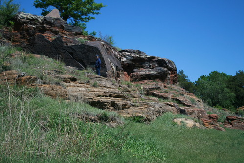
Pawnee Rock with trees and a man in frame; To travelers on the Santa Fe Trail, this sandstone citadel marked the halfway point of the trail and was one of the most prominent landmarks on their long journey. American Indians were said to have met at Pawnee Rock and reputedly used it as a vantage point to spot bison herds and approaching wagon trains. At times, travelers on the Santa Fe Trail regarded it as the most dangerous place they had to pass. However, it was also a welcome landmark for travelers, signaling that about half of their journey was now behind them. Hundreds stopped to write their names in the soft sandstone beside the ancient drawings that the Indians had engraved before.;
U.S. National Park Service
Permission must be secured from the individual copyright owners to reproduce any copyrighted materials contained within this website.
Public domain
Kansas, (SanteFe Trail State)
Image
Santa Fe National Historic Trail, Code: SAFE
Great Bend ; PR Four Trails ; Cherokee Trail ; Pawnee Rock, Barton County, Kansas
Santa Fe National Historic Trail
Latitude: 37.9892997741699, Longitude: -99.3414993286133
Santa Fe National Historic Trail
Latitude: 37.9892997741699, Longitude: -99.3414993286133
20150511
05/11/2015
Shot On: Canon EOS DIGITAL REBEL XTi; Dimensions 2816 x 1880; Shot 1/800 sec. f/4.5 33mm; ISO 100; Size 2.6 MB
Public Can View
Organization: US National Park Service
Address: PO Box 728, Santa Fe, New Mexico 87504, Phone:(505) 988-6098
Email: ntir_information@NPS.gov
Address: PO Box 728, Santa Fe, New Mexico 87504, Phone:(505) 988-6098
Email: ntir_information@NPS.gov
Tuesday, November 3, 2020 3:16:24 PM
Tuesday, November 3, 2020 3:16:24 PM
SAFE_KS_GreatBend_PRFourTrails_CherokeeTrail_PawneeRock_20150511_NPS_(12).JPG
jpg
2.7 MB
Scenic
,
Historic