Select Item below to DOWNLOAD - Once item is selected, right click and choose 'save as'
1d10194e80f94d19ad3fbac96cbdb0f9
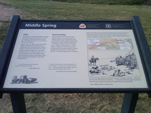
"Middle Spring" wayside at Cimarron National Grassland
A wayside titled "Middle Spring" with some text and illustration on it in a grassy field.
Middle Spring wayside; Middle Spring is 8 miles north of Elkhart on Kansas Hwy 27, about 1 mile west on a dirt road to a small enclosed park. After Lower Spring, this was the next reliable water source, making it a major stopping point along the trail; https://www.nps.gov/nr/feature/places/13000136.htm; https://www.fs.usda.gov/rmrs/geography/cimarron-national-grassland
U.S. National Park Service
Permission must be secured from the individual copyright owners to reproduce any copyrighted materials contained within this website.
Public domain
Kansas, (SanteFe Trail State)
Image
Santa Fe National Historic Trail, Code: SAFE
Stevens County ; Cimarron National Grassland, Morton County, Kansas
Santa Fe National Historic Trail
Latitude: 37.9892997741699, Longitude: -99.3414993286133
Santa Fe National Historic Trail
Latitude: 37.9892997741699, Longitude: -99.3414993286133
20130927
09/27/2013
Shot On: BlackBerry 9650; Dimensions 2048 x 1536; 805.6 KB
Public Can View
Organization: US National Park Service
Address: PO Box 728, Santa Fe, New Mexico 87504, Phone:(505) 988-6098
Email: ntir_information@NPS.gov
Address: PO Box 728, Santa Fe, New Mexico 87504, Phone:(505) 988-6098
Email: ntir_information@NPS.gov
Tuesday, November 3, 2020 4:23:07 PM
Tuesday, November 3, 2020 4:23:07 PM
SAFE_KS_Cimarron NationalGrassland_20130927_NPS_(11).JPG
jpg
825.0 kB
Scenic
,
Historic