Select Item below to DOWNLOAD - Once item is selected, right click and choose 'save as'
e221276ef4f9490091599fccfe1ed983
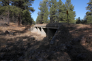
Concrete Culvert on the 1931 paved route about 1/2 mi. W. of Devil Dog Rd. (I-40 Exit 157).
Concrete Culvert on the 1931 paved route about 1/2 mi. W. of Devil Dog Rd. (I-40 Exit 157).
4-barrel Concrete Culvert; Open to traffic
U.S. National Park Service
IN COPYRIGHT. This Item is protected by copyright and/or related rights. Copyright: Ross, Jim
Jim Ross
Restrictions apply on use and/or reproduction:Copyrighted material
Image
Route 66 Corridor Preservation Program, Code: ROSI
Coconino County, Arizona
Latitude: 35.214596, Longitude: -112.283931
Latitude: 35.214596, Longitude: -112.283931
20131113
01/01/1930
Public Can View
Organization: National Trails, US National Park Service
Address: Route 66 Corridor Preservation Program, PO Box 728 Santa Fe, NM 87505, Phone: (505) 988-6701
Email: IM_RT66@nps.gov
Address: Route 66 Corridor Preservation Program, PO Box 728 Santa Fe, NM 87505, Phone: (505) 988-6701
Email: IM_RT66@nps.gov
Thursday, May 28, 2020 10:38:33 AM
Thursday, May 28, 2020 10:38:33 AM
27-IMG_5905.jpg
jpg
10.3 MB
Inventory