Select Item below to DOWNLOAD - Once item is selected, right click and choose 'save as'
685ba1ee35024452b22bb19b2a8ba892
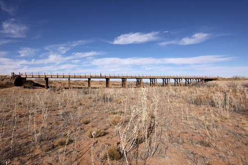
4th Timber bridge on Trujillo Creek on first paved route W. of Glenrio (on offset alignment).
4th Timber bridge on Trujillo Creek on first paved route W. of Glenrio (on offset alignment).
Timber Stringer with asphalt deck; Open to traffic
U.S. National Park Service
IN COPYRIGHT. This Item is protected by copyright and/or related rights. Copyright: Ross, Jim
Jim Ross
Restrictions apply on use and/or reproduction:Copyrighted material
Image
Route 66 Corridor Preservation Program, Code: ROSI
Quay County, New Mexico
Latitude: 35.123533, Longitude: -103.144726
Latitude: 35.123533, Longitude: -103.144726
20130217
01/01/1931
Public Can View
Organization: National Trails, US National Park Service
Address: Route 66 Corridor Preservation Program, PO Box 728 Santa Fe, NM 87505, Phone: (505) 988-6701
Email: IM_RT66@nps.gov
Address: Route 66 Corridor Preservation Program, PO Box 728 Santa Fe, NM 87505, Phone: (505) 988-6701
Email: IM_RT66@nps.gov
Thursday, May 28, 2020 9:08:33 AM
Thursday, May 28, 2020 9:08:33 AM
5-IMG_0374FNM.JPG
jpg
9.7 MB
Inventory