Select Item below to DOWNLOAD - Once item is selected, right click and choose 'save as'
de5376ff-397c-4164-94fd-032835090d55
Big Hole Battlefield Trail Big Hole National Battlefield 2019
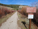
Trail signage showing distance
The Big Hole Battlefield Trail begins in the Sula Basin of the Bitterroot Range, crosses the Continental Divide, then follows Trail Creek for about sixteen miles to the western park boundary of Big Hole National Battlefield.
U.S. National Park Service
IN COPYRIGHT. This Item is protected by copyright and/or related rights. Copyright: David Lingle
David Lingle
Restrictions apply on use and/or reproduction:Copyrighted material
Image
National Trails System, Code: NTS
Big Hole National Battlefield, Code: BIHO
Big Hole National Battlefield, Code: BIHO
At Big Hole National Battlefield, ten miles west of Wisdom, MT on SH 43, In Gallatin National Forest, N of Earthquake Lake on SR 287.
Big Hole National Battlefield, Beaverhead County, Montana
Latitude: 45.646900177002, Longitude: -113.650001525879
Big Hole National Battlefield, Beaverhead County, Montana
Latitude: 45.646900177002, Longitude: -113.650001525879
10/15/2019 12:00:00 AM
07/06/2021
Public Can View
Person: David Lingle
Organization: Big Hole NB
Address: Wisdom, MT
Organization: Big Hole NB
Address: Wisdom, MT
Wednesday, August 11, 2021 1:31:23 PM
Wednesday, August 11, 2021 1:31:23 PM
Big Hole Battlefield Trail 7.jpg
jpg
2.0 MB
Scenic