Select Item below to DOWNLOAD - Once item is selected, right click and choose 'save as'
634f6859ad344d4498f3f8d7becc69f1
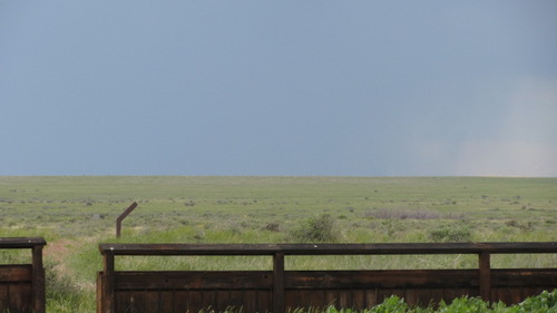
Metal fence in the field, with storms on the horizon at Timpas Picnic Area
A view of a plain landscape with a dark sky and rain in the distance, behind a metal barrier.
Start your hike at the nature trail and walk northwest to the stone trail post or, if you are on horseback, start your ride at the stock tank, following the fence northwest to the gate. From there turn northwest and go through the gate following the stone trail posts to Sierra Vista; https://www.fs.usda.gov/recarea/psicc/recarea/?recid=12442; General Location- 37.82343345; -103.7710063; 4420 feet
U.S. National Park Service
Permission must be secured from the individual copyright owners to reproduce any copyrighted materials contained within this website.
Public domain
Colorado, (SanteFe Trail State)
Image
Santa Fe National Historic Trail, Code: SAFE
La Junta ; Comanche Grassland ; Sierra Vista, Otero County, Colorado
Santa Fe National Historic Trail
Latitude: 37.9892997741699, Longitude: -99.3414993286133
Santa Fe National Historic Trail
Latitude: 37.9892997741699, Longitude: -99.3414993286133
20150528
05/28/2015
Shot On: Canon PowerShot SX 230 HS; Dimensions 640 x 360; Shot 1/320 sec. f/5 37.91mm; ISO 125; Size 59.8 KB
Public Can View
Organization: US National Park Service
Address: PO Box 728, Santa Fe, New Mexico 87504, Phone:(505) 988-6098
Email: ntir_information@NPS.gov
Address: PO Box 728, Santa Fe, New Mexico 87504, Phone:(505) 988-6098
Email: ntir_information@NPS.gov
Tuesday, November 3, 2020 4:46:02 PM
Tuesday, November 3, 2020 4:46:02 PM
SAFE_CO_OteroCounty_LaJunta_ComancheNationalGrassland_TimpasPicnicArea_20150528_NPS_(14).JPG
jpg
61.3 kB
Scenic
,
Historic