Select Item below to DOWNLOAD - Once item is selected, right click and choose 'save as'
9c81c835-8302-4484-a4bd-46218850e2c2
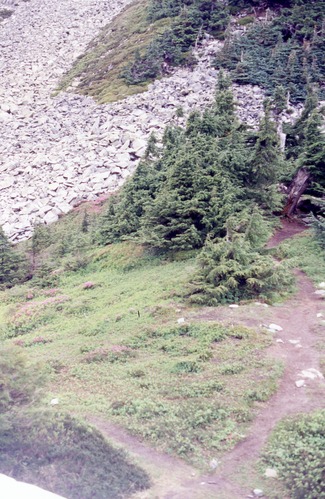
Trail to Pelton Basin from Cascade Pass near site TH4, July 2002, 2 of 5
A trail leading through a patch of trees and down into a pit of rocks.
Cascade Pass, Revegetation Site TH4, revegetation monitoring photograph. Text on slide frame reads: "REV/CAS/TH4/a-12, #2 in series, Cascade Pass, From snow looking to Nill C1/Thx 4, 5, 6, 7, 7/2002." (North Cascades NPS Complex Museum Collection, NOCA.0013 Revegetation Program Records, Series XI: Photographs, File 001 - Cascade Pass, Vicinity Impacts and Revegetation Sites, 1970-2004)
U.S. National Park Service
This digital asset is in the public domain. When using this asset for any purpose, including online, credit: 'Courtesy of North Cascades NPS Complex Museum Collection, Revegetation Program Records.'
NPS Photo
Public domain
Native Plant Restoration, (North Cascades Program)
, Cascade Pass, (North Cascades Locality)
, Revegetation, (North Cascades Activity)
, Cascade Pass, (North Cascades Locality)
, Revegetation, (North Cascades Activity)
Image
North Cascades National Park, Code: NOCA
North Cascades National Park, Washington
Latitude: 48.8278884887695, Longitude: -121.35050201416
Cascade Pass
Latitude: 48.8278884887695, Longitude: -121.35050201416
Cascade Pass
ICMS Archives Module : NOCA.0013.11.001
2024/01/30
01/01/2002 - 12/30/2002
slide transparency
Curation Facility
Public Can View
Person: NOCA Curator
Organization: North Cascades NPS Complex
Position: Museum Curator
Address: 7280 Ranger Station Road, Marblemount, WA 98267
Email: NOCA_Curator@nps.gov.
Organization: North Cascades NPS Complex
Position: Museum Curator
Address: 7280 Ranger Station Road, Marblemount, WA 98267
Email: NOCA_Curator@nps.gov.
Thursday, January 30, 2025 5:39:42 PM
Thursday, January 30, 2025 5:39:42 PM
0013.11.001.0299.tif
tif
37.7 MB
Monitoring