Select Item below to DOWNLOAD - Once item is selected, right click and choose 'save as'
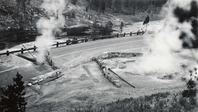
Beryl Spring Road
1942
Interpretive text from United States Geological Survey Volcano Hazards Program:
Beryl Spring is a hydrothermal area in some restrictive topography! The road from Norris Geyser Basin to Madison Junction follows the Gibbon River through a tight valley. With not much of a choice, the road threads between the river and Beryl Spring over some exceedingly hot ground. It takes a feat of engineering to keep the road drivable through this area, and sometimes nature has the final say, as in this photograph. The road is currently passable by bison and automobiles.
National Park Service photograph
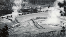