Select Item below to DOWNLOAD - Once item is selected, right click and choose 'save as'
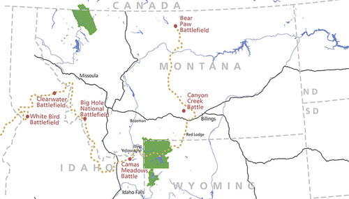
Map of the 1877 Flight of the Nez Perce
2021
The dashed yellow line illustrates the path of the Nez Perce Flight of 1877, an arduous journey of more than 1,1700 miles in which approximately 800 men, women, and children on foot and horseback crossed Idaho, Wyoming, and Montana, with the United States Army in close pursuit. The red dots indicate the locations of six battles.
The Nez Perce Flight toward their ally, Lakota Chief Sitting Bull, in Canada included 13 days spent crossing Yellowstone National Park. They traveled into present day Montana before they were captured by the U.S. Cavalry fifty miles from the international border.
Although the time spent in Yellowstone National Park represented a small portion of the long flight, the time the Nez Perce spent in Yellowstone remains a very significant part of Nez Perce cultural history.
For additional information, see Nez Perce National Historic Site (https://www.nps.gov/nepe/index.htm).
Yellowstone Spatial Analysis Center