Select Item below to DOWNLOAD - Once item is selected, right click and choose 'save as'
vref-020075.tif
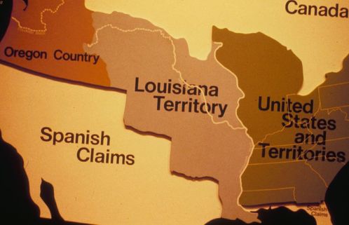
Map of the US showing Oregon Country, Spanish Claims, Louisiana Territory and US Territory in the Lewis and Clark Slide Program.
Map of the US showing Oregon Country, Spanish Claims, Louisiana Territory and US Territory in the Lewis and Clark Slide Program.
National Park Service
To the best of our knowledge we believe this image to by copyright free and in the public domain.
Public domain
Image
Gateway Arch National Park, Code: JEFF
01/16/2001 01:00:00
Public Can View
Person: Archivist
Organization: US National Park Service
Position: Cultural Resource Management
Address: Jefferson National Expansion Memorial, 11 North Fourth Street, St. Louis, MO 63110, Phone: 314.655.1600
Email: jeff_archivist@nps.gov
Organization: US National Park Service
Position: Cultural Resource Management
Address: Jefferson National Expansion Memorial, 11 North Fourth Street, St. Louis, MO 63110, Phone: 314.655.1600
Email: jeff_archivist@nps.gov
Tuesday, April 18, 2017 3:08:47 AM
Tuesday, April 18, 2017 3:08:47 AM
tif
2.9 MB
Historic
Imagenum: VREF-020075
dbd5e944bfae42ed8b00a8f9db7776c0
Monday, January 1, 0001 12:00:00 AM