Select Item below to DOWNLOAD - Once item is selected, right click and choose 'save as'
c46d78ce57a843cf90a0460dd2f02b0a
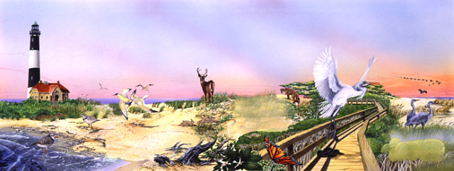
Barrier Island profile: Illustrated compressed panorama of ocean/beach, dune/forest, and marsh/bay habitats representing the interdependence of the ecological zones
Barrier Island profile: Illustrated compressed panorama of ocean/beach, dune/forest, and marsh/bay habitats representing the interdependence of the ecological zones
Within the habitats are Piping plovers, gulls, rabbits, a deer, fox, monarch butterfly, egret, herons, a snake, and geese in flight The flora is represented by grasses including American beach grass, poison ivy, and the "sunken forest" Man's presence is shown by the board-walk, lighthouse, and keeper's quarters
Abbr=PUB
U.S. National Park Service
Project=Folder; Art_Registration_No=PUB-0095; Reflective Art
Government owns art and all reproduction rights.
Public domain
Image
Fire Island National Seashore, Code: FIIS
Fire Island National Seashore, Suffolk County, New York
Latitude: 40.6917991638184, Longitude: -72.9944000244141
Latitude: 40.6917991638184, Longitude: -72.9944000244141
Image Management System : IMS 08374
20190904
01/01/1994 - 12/30/1994
Image_Size=32" x 14"; Count:1/1; Fire Island National Seashore park brochure
R3
Public Can View
Organization: Harpers Ferry Center
Address: Harpers Ferry Center, 67 Mather Place, Harpers Ferry, WV, 25425, 304-535-5050
Address: Harpers Ferry Center, 67 Mather Place, Harpers Ferry, WV, 25425, 304-535-5050
Friday, October 4, 2019 1:17:24 PM
Friday, October 4, 2019 1:17:24 PM
08374.jpg
jpg
51.6 kB
Museum