Select Item below to DOWNLOAD - Once item is selected, right click and choose 'save as'
c2fcf3ce96fb43949e6970a4b67c96a5
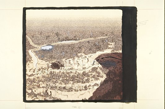
Aerial view depicts the area around Long House and the trail leading to the site.
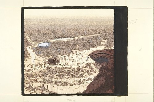
Aerial view depicts the area around Long House and the trail leading to the site.
Illustration Reference Source: National Geographic, February 1964, page 165; Abbr=WE
U.S. National Park Service
Project=Wetherill Mesa; Reflective Art
Government owns art and all reproduction rights.
Public domain
Image
Mesa Verde National Park, Code: MEVE
Mesa Verde National Park, Montezuma County, Colorado
Latitude: 37.2234992980957, Longitude: -108.500999450684
Latitude: 37.2234992980957, Longitude: -108.500999450684
Image Management System : IMS 04196
20190904
01/01/1971 - 12/30/1971
Image_Size=23-1/2" x 18"; Exhibit 8: "Trail for Long House Tour" Graphic # 8-7 (old), Exhibit 16: "Long House Overlook" Graphic # 16-8 (old), and Exhibit 22: "Long House Overlook" Graphic # 22-7 (old)
S6
Public Can View
Organization: Harpers Ferry Center
Address: Harpers Ferry Center, 67 Mather Place, Harpers Ferry, WV, 25425, 304-535-5050
Address: Harpers Ferry Center, 67 Mather Place, Harpers Ferry, WV, 25425, 304-535-5050
Friday, October 4, 2019 2:27:23 PM
Friday, October 4, 2019 2:27:23 PM
04196.JPG
jpg
48.2 kB
Museum