Select Item below to DOWNLOAD - Once item is selected, right click and choose 'save as'
78ad4cd98cf643f4895ee8b0b484269b
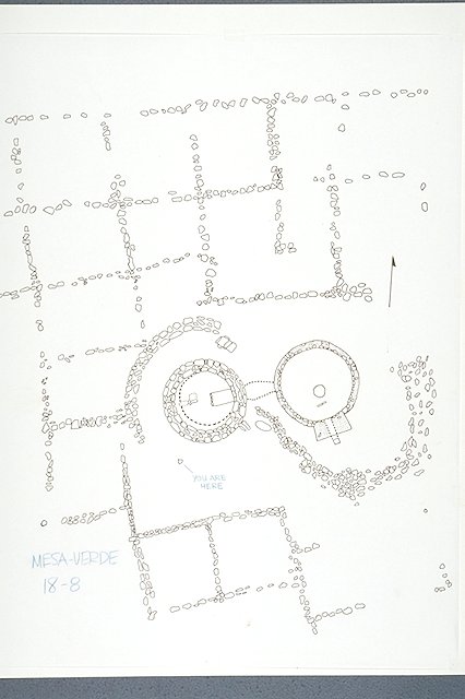
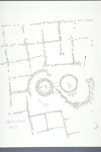
A site plan view of Sun Point Pueblo highlighting the size and complexity of the pueblo by showing the remains of fifteen room foundations which surround the tower and kiva.
A site plan view of Sun Point Pueblo highlighting the size and complexity of the pueblo by showing the remains of fifteen room foundations which surround the tower and kiva.
Abbr=WE
U.S. National Park Service
Project=Chapin Mesa/Mesa Top Ruins; Art_Registration_No=WE-0004 ; Reflective Art
Government owns art and all reproduction rights.
Public domain
Architecture, (HFC ArtTheme)
, Felt tip marker on tracing paper affixed to heavy stock paper, (HFC ArtMedium)
, Felt tip marker on tracing paper affixed to heavy stock paper, (HFC ArtMedium)
Image
Mesa Verde National Park, Code: MEVE
Mesa Verde National Park, Montezuma County, Colorado
Latitude: 37.2234992980957, Longitude: -108.500999450684
Latitude: 37.2234992980957, Longitude: -108.500999450684
Image Management System : IMS 04497
20190904
01/01/1987 - 12/30/1987
Image_Size=13-5/16" x 17-7/16"; Count:7/9; Exhibit 18: "Sun Point Pueblo" Graphic # 18-8
I 14
Public Can View
Organization: Harpers Ferry Center
Address: Harpers Ferry Center, 67 Mather Place, Harpers Ferry, WV, 25425, 304-535-5050
Address: Harpers Ferry Center, 67 Mather Place, Harpers Ferry, WV, 25425, 304-535-5050
Wednesday, October 9, 2019 12:44:13 PM
Wednesday, October 9, 2019 12:44:13 PM
04497.JPG
jpg
41.3 kB
Museum