Select Item below to DOWNLOAD - Once item is selected, right click and choose 'save as'
4ad2cd721b344d679a713737d3d58342
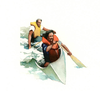
Illustration depicts the swamping of a canoe. Two canoeists leaning upstream cause water to run over the gunwale, filling the canoe.
Illustration depicts the swamping of a canoe. Two canoeists leaning upstream cause water to run over the gunwale, filling the canoe.
Abbr=PUB
U.S. National Park Service
Project=Folder; Reflective Art
Government owns art and all reproduction rights.
Public domain
Image
Ozark National Scenic Riverways, Code: OZAR
Ozark National Scenic Riverways, Missouri
Latitude: 37.2426986694336, Longitude: -91.3555526733398
Latitude: 37.2426986694336, Longitude: -91.3555526733398
Image Management System : IMS 07305
20190904
01/01/1986 - 12/30/1986
Image_Size=10" x 10"; Count:10/21; Ozark National Scenic Riverways park brochure
MC D3
Public Can View
Organization: Harpers Ferry Center
Address: Harpers Ferry Center, 67 Mather Place, Harpers Ferry, WV, 25425, 304-535-5050
Address: Harpers Ferry Center, 67 Mather Place, Harpers Ferry, WV, 25425, 304-535-5050
Friday, October 4, 2019 1:50:00 PM
Friday, October 4, 2019 1:50:00 PM
07305.jpg
jpg
34.1 kB
Museum