Select Item below to DOWNLOAD - Once item is selected, right click and choose 'save as'
321bbf42b74d4863943c7fc2432df4fc
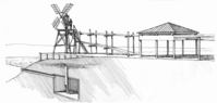
A diagram of a saltworks showing location near a saltwater source and how water was pumped into the vats.
A diagram of a saltworks showing location near a saltwater source and how water was pumped into the vats.
Abbr=EX
U.S. National Park Service
Project=Salt Pond; Art_Registration_No=EPD-0014 ; Reflective Art
Government owns art and all reproduction rights.
Public domain
Pen and ink on paper, (HFC ArtMedium)
Image
Cape Cod National Seashore, Code: CACO
Cape Cod National Seashore, Barnstable County, Massachusetts
Latitude: 41.959098815918, Longitude: -70.0053024291992
Latitude: 41.959098815918, Longitude: -70.0053024291992
Image Management System : IMS 06660
20190904
01/01/1988 - 12/30/1988
Graphic # CC-G-526
J7
Public Can View
Organization: Harpers Ferry Center
Address: Harpers Ferry Center, 67 Mather Place, Harpers Ferry, WV, 25425, 304-535-5050
Address: Harpers Ferry Center, 67 Mather Place, Harpers Ferry, WV, 25425, 304-535-5050
Thursday, October 3, 2019 4:33:33 PM
Thursday, October 3, 2019 4:33:33 PM
06660.jpg
jpg
39.6 kB
Museum