Select Item below to DOWNLOAD - Once item is selected, right click and choose 'save as'
228be4448bc84e7bbdb98868f304706e
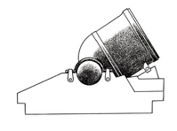
Profile of a 10-inch siege mortar
Profile of a 10-inch siege mortar
Illustrated with FOSU's Exhibit 9/Graphic # 9-10, Exhibit 9/Graphic # 9-11, Exhibit 9/Graphic # 9-12, Exhibit 9/Graphic # 9-13, Exhibit 9/Graphic # 9-16 and FOMO's Exhibit 21/Graphic # 21-14, Exhibit 21/Graphic # 21-16; Abbr=WE
U.S. National Park Service
Art_Registration_No=WE-0141 ; Reflective Art
Government owns art and all reproduction rights.
Public domain
Fortifications/Coastal Defenses, (HFC ArtTheme)
, Pen and ink on illustration board, (HFC ArtMedium)
, Pen and ink on illustration board, (HFC ArtMedium)
Image
Fort Moultrie National Monument, Code: FOMO
Fort Moultrie National Monument, Charleston County, South Carolina
Latitude: 32.7585105895996, Longitude: -79.8576126098633
Latitude: 32.7585105895996, Longitude: -79.8576126098633
Image Management System : IMS 08642
20190904
01/01/1994 - 12/30/1994
Image_Size=7-1/2" x 5"; Count:20/23; Exhibit 9/Graphic # 9-15 (FOSU) and Exhibit 21/Graphic # 21-11 (Fort Moultrie)
Q2
Public Can View
Organization: Harpers Ferry Center
Address: Harpers Ferry Center, 67 Mather Place, Harpers Ferry, WV, 25425, 304-535-5050
Address: Harpers Ferry Center, 67 Mather Place, Harpers Ferry, WV, 25425, 304-535-5050
Monday, October 7, 2019 2:40:30 PM
Monday, October 7, 2019 2:40:30 PM
08642.jpg
jpg
39.8 kB
Museum