Select Item below to DOWNLOAD - Once item is selected, right click and choose 'save as'
0f8eafaae85f4638a28253ae1647645e
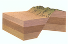
A block diagram of the broad, flat Utah Valley from a south-to-north perspective in contrast to the steeply rising mountains
A block diagram of the broad, flat Utah Valley from a south-to-north perspective in contrast to the steeply rising mountains
depicts the geologically unstable conditions in this "earthquake zone", the illustration identifies how the rock layers on either side of a fault line slip past each other.
Abbr=WE
U.S. National Park Service
Art_Registration_No=WE-0249 ; Reflective Art
Government owns art and all reproduction rights.
Public domain
Image
Timpanogos Cave National Monument, Code: TICA
Timpanogos Cave National Monument, Utah County, Utah
Latitude: 40.4403991699219, Longitude: -111.708999633789
Latitude: 40.4403991699219, Longitude: -111.708999633789
Image Management System : IMS 09155
20190904
01/01/2002 - 12/30/2002
Image_Size=11" x 9"; Count:2/2; Exhibit 8: " Earthquake Zone"
L4
Public Can View
Organization: Harpers Ferry Center
Address: Harpers Ferry Center, 67 Mather Place, Harpers Ferry, WV, 25425, 304-535-5050
Address: Harpers Ferry Center, 67 Mather Place, Harpers Ferry, WV, 25425, 304-535-5050
Monday, October 7, 2019 2:37:06 PM
Monday, October 7, 2019 2:37:06 PM
09155.jpg
jpg
186.8 kB
Museum