Select Item below to DOWNLOAD - Once item is selected, right click and choose 'save as'
0bf652648cc94c0fbc10783dde5678e0
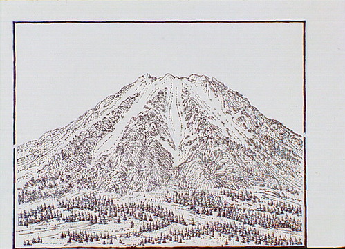
One section of a four-part illustration showing how the glacial "notches" on the caldera wall were formed. Glaciers formed on the upper slopes, growing larger during the Ice Age.
One section of a four-part illustration showing how the glacial "notches" on the caldera wall were formed. Glaciers formed on the upper slopes, growing larger during the Ice Age.
Abbr=WE
U.S. National Park Service
Reflective Art
Government owns art and all reproduction rights.
Public domain
Image
Crater Lake National Park, Code: CRLA
Crater Lake National Park, Oregon
Latitude: 42.9442710876465, Longitude: -122.135299682617
Latitude: 42.9442710876465, Longitude: -122.135299682617
Image Management System : IMS 00647
20190904
01/01/1985 - 12/30/1985
Exhibit 23/Graphic # 23-6 and Exhibit 41/Graphic # 41-3
Q5
Public Can View
Organization: Harpers Ferry Center
Address: Harpers Ferry Center, 67 Mather Place, Harpers Ferry, WV, 25425, 304-535-5050
Address: Harpers Ferry Center, 67 Mather Place, Harpers Ferry, WV, 25425, 304-535-5050
Monday, October 7, 2019 3:10:19 PM
Monday, October 7, 2019 3:10:19 PM
00647.JPG
jpg
116.8 kB
Museum