Select Item below to DOWNLOAD - Once item is selected, right click and choose 'save as'
e6e19d73-fae6-4968-8c44-331dd9378ab2
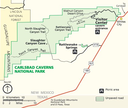
Park Map - Carlsbad Caverns National Park
Map of Carlsbad Caverns National Park in New Mexico. The park is represented as an oblong green shape, stretching across in the west-to-east direction that tapers toward the top, with staircase-like staggered boundaries. A chunk of land shaded yellow that runs down most of the left edge from the top corner is labeled Lincoln National Forest. The Guadalupe Mountains run down the western edge of the map through both the national park and national forest.
Screen-viewable file; Adobe print production files can be downloaded from the Compressed zip Version link
Map Projection: Other; Map Type: park map
U.S. National Park Service
The National Park Service maps are government produced and are in the public domain. Anyone may, without restriction under U.S. copyright laws: Reproduce the work in print or digital form; Create derivative works; Perform the work publicly; Display the work; Distribute copies or digitally transfer the work to the public by sale or other transfer of ownership, or by rental, lease, or lending. Please note, a user who modifies and/or republishes National Park Service maps are responsible for any problems encountered with the maps, due to their change or modification.
Public domain
Document
Carlsbad Caverns National Park, Code: CAVE
Carlsbad Caverns National Park, Eddy County, New Mexico
Latitude: 32.1408996582031, Longitude: -104.553001403809
Latitude: 32.1408996582031, Longitude: -104.553001403809
2018-06-18
Public Can View
Person: Harpers Ferry Center
Organization: US National Park Service
Address: Harpers Ferry Center, Harpers Ferry, WV
Email: HFC_Cartography@nps.gov
Organization: US National Park Service
Address: Harpers Ferry Center, Harpers Ferry, WV
Email: HFC_Cartography@nps.gov
Monday, April 25, 2022 4:47:02 PM
Friday, September 26, 2025 11:34:26 PM
CAVEmap1.pdf
pdf
207.4 kB
Map