Select Item below to DOWNLOAD - Once item is selected, right click and choose 'save as'
e3de5810519e49b681e1533d745b7cee
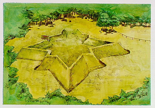
Aerial view of the earthworks of Fort Raleigh.
Aerial view of the earthworks of Fort Raleigh.
Abbr=AVA
U.S. National Park Service
Reflective Art
Government owns art and all reproduction rights.
Public domain
Image
Fort Raleigh National Historic Site, Code: FORA
Fort Raleigh National Historic Site, Dare County, North Carolina
Latitude: 35.9364013671875, Longitude: -75.7093963623047
Latitude: 35.9364013671875, Longitude: -75.7093963623047
Image Management System : IMS 01865
20190904
01/01/1968 - 12/30/1968
Image_Size=W: 20" x H: 15"; Metric_Size=W: 50.76CM X H: 38.07CM; AVA Project #51, Plate 47
C15
Public Can View
Organization: Harpers Ferry Center
Address: Harpers Ferry Center, 67 Mather Place, Harpers Ferry, WV, 25425, 304-535-5050
Address: Harpers Ferry Center, 67 Mather Place, Harpers Ferry, WV, 25425, 304-535-5050
Wednesday, October 9, 2019 3:49:50 PM
Wednesday, October 9, 2019 3:49:50 PM
01865.JPG
jpg
119.5 kB
Museum