Select Item below to DOWNLOAD - Once item is selected, right click and choose 'save as'
e08f3863bc5a448fa3d7c7638a8b8409
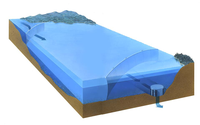
Illustration of the water curtain in Whiskeytown Lake and how it prevents the sun-warmed surface water from mixing with the deeper, colder lake water before it is discharged into the Sacramento River.
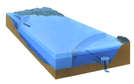
Illustration of the water curtain in Whiskeytown Lake and how it prevents the sun-warmed surface water from mixing with the deeper, colder lake water before it is discharged into the Sacramento River.
Abbr=WE
U.S. National Park Service
Art_Registration_No=WE-0217; Reflective Art
Government owns art and all reproduction rights.
Public domain
Image
Whiskeytown National Recreation Area, Code: WHIS
Whiskeytown National Recreation Area, Shasta County, California
Latitude: 40.6136016845703, Longitude: -122.601997375488
Latitude: 40.6136016845703, Longitude: -122.601997375488
Image Management System : IMS 09749
20190904
01/01/1999 - 12/30/1999
Image_Size=13" x 20-1/2"; Count:1/1; 32-WHIS-02
T13
Public Can View
Organization: Harpers Ferry Center
Address: Harpers Ferry Center, 67 Mather Place, Harpers Ferry, WV, 25425, 304-535-5050
Address: Harpers Ferry Center, 67 Mather Place, Harpers Ferry, WV, 25425, 304-535-5050
Friday, October 4, 2019 12:31:36 PM
Friday, October 4, 2019 12:31:36 PM
09749.jpg
jpg
43.0 kB
Museum