Select Item below to DOWNLOAD - Once item is selected, right click and choose 'save as'
d66e5fe9cd244d5fbbbbacd9838f4e00
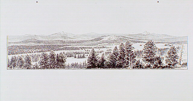
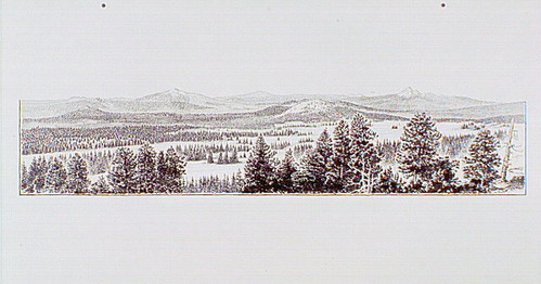
Panoramic view looking north at Bald Crater and continuing east to Pumice Desert. Also highlighted are Garwood Butte, Mount Bailey, Diamond Peak, Diamond Lake, Red Cone, Three Sisters, and Mount Thielsen.
Panoramic view looking north at Bald Crater and continuing east to Pumice Desert. Also highlighted are Garwood Butte, Mount Bailey, Diamond Peak, Diamond Lake, Red Cone, Three Sisters, and Mount Thielsen.
Illustration based on a series of photographs taken from the exhibit site.; Abbr=WE
U.S. National Park Service
Reflective Art
Government owns art and all reproduction rights.
Public domain
Image
Crater Lake National Park, Code: CRLA
Crater Lake National Park, Oregon
Latitude: 42.9442710876465, Longitude: -122.135299682617
Latitude: 42.9442710876465, Longitude: -122.135299682617
Image Management System : IMS 00667
20190904
01/01/1985 - 12/30/1985
Exhibit 16/Graphic # 16-9 and Exhibit 17/Graphic # 17-9
Q5
Public Can View
Organization: Harpers Ferry Center
Address: Harpers Ferry Center, 67 Mather Place, Harpers Ferry, WV, 25425, 304-535-5050
Address: Harpers Ferry Center, 67 Mather Place, Harpers Ferry, WV, 25425, 304-535-5050
Friday, October 4, 2019 2:54:27 PM
Friday, October 4, 2019 2:54:27 PM
00667.JPG
jpg
55.9 kB
Museum