Select Item below to DOWNLOAD - Once item is selected, right click and choose 'save as'
d37a17ea-ca39-4656-91f4-56624ff42205
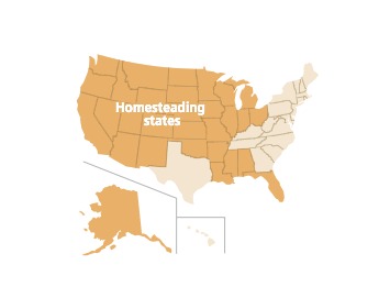
Homesteading States - Homestead National Historical Park
Map showing homesteading states in the United States. The homesteading states are shown in gold and non-homesteading states are beige. All states are outlined in gray, but individual states are not labeled.
Screen-viewable file; Adobe print production files can be downloaded from the Compressed zip Version link
Map Projection: Other; Map Type: unassigned
U.S. National Park Service
The National Park Service maps are government produced and are in the public domain. Anyone may, without restriction under U.S. copyright laws: Reproduce the work in print or digital form; Create derivative works; Perform the work publicly; Display the work; Distribute copies or digitally transfer the work to the public by sale or other transfer of ownership, or by rental, lease, or lending. Please note, a user who modifies and/or republishes National Park Service maps are responsible for any problems encountered with the maps, due to their change or modification.
Public domain
Document
Homestead National Historical Park, Code: HOME
Homestead National Historical Park, Nebraska
Homestead National Historical Park, Gage County, Nebraska
Latitude: 40.2879981994629, Longitude: -96.8339004516602
Homestead National Historical Park, Gage County, Nebraska
Latitude: 40.2879981994629, Longitude: -96.8339004516602
2021-08-04
Public Can View
Person: Harpers Ferry Center
Organization: US National Park Service
Address: Harpers Ferry Center, Harpers Ferry, WV
Email: HFC_Cartography@nps.gov
Organization: US National Park Service
Address: Harpers Ferry Center, Harpers Ferry, WV
Email: HFC_Cartography@nps.gov
Tuesday, April 26, 2022 9:29:04 PM
Friday, September 26, 2025 11:35:50 PM
HOMEmap2.pdf
pdf
604.9 kB
Map