Select Item below to DOWNLOAD - Once item is selected, right click and choose 'save as'
d19627b9-5c3c-4c66-b8b1-fbc98b814ba4
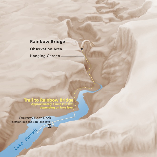
3D Trail Map - Rainbow Bridge National Monument
Trail map of Rainbow Bridge National Monument in Utah. Lake Powell winds along the floor of a curving canyon, which is shown in tan. A trail is represented as a yellow dashed line.
Screen-viewable file; Adobe print production files can be downloaded from the Compressed zip Version link
Map Projection: Other; Map Type: detail
U.S. National Park Service
The National Park Service maps are government produced and are in the public domain. Anyone may, without restriction under U.S. copyright laws: Reproduce the work in print or digital form; Create derivative works; Perform the work publicly; Display the work; Distribute copies or digitally transfer the work to the public by sale or other transfer of ownership, or by rental, lease, or lending. Please note, a user who modifies and/or republishes National Park Service maps are responsible for any problems encountered with the maps, due to their change or modification.
Public domain
Document
Rainbow Bridge National Monument, Code: RABR
Rainbow Bridge National Monument, San Juan County, Utah
Latitude: 37.0778999328613, Longitude: -110.966003417969
Latitude: 37.0778999328613, Longitude: -110.966003417969
2018-10-29
Public Can View
Person: Harpers Ferry Center
Organization: US National Park Service
Address: Harpers Ferry Center, Harpers Ferry, WV
Email: HFC_Cartography@nps.gov
Organization: US National Park Service
Address: Harpers Ferry Center, Harpers Ferry, WV
Email: HFC_Cartography@nps.gov
Monday, May 2, 2022 9:40:15 PM
Friday, September 26, 2025 11:37:10 PM
RABR3Dtrailmap.pdf
pdf
10.3 MB
Map