Select Item below to DOWNLOAD - Once item is selected, right click and choose 'save as'
c15a4bf18c46442988a1da46414434d1
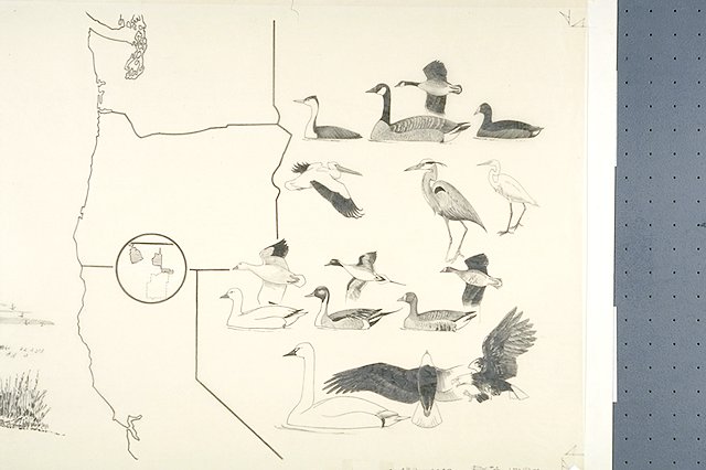
Split panel depicts a map of the Pacific Flyway showing the location of the Klamath River Refuges; a map of the Klamath Basin Wildlife Refuges, showing their relation to Lava Beds National Monument; and a seasonal identification chart showing representativ
Split panel depicts a map of the Pacific Flyway showing the location of the Klamath River Refuges; a map of the Klamath Basin Wildlife Refuges, showing their relation to Lava Beds National Monument; and a seasonal identification chart showing representative species according to seasons of the year
Birds shown include (Spring) Western grebe, Canada goose, Coot; (Summer) White pelican, Great Blue heron, Common egret; (fall) Snow goose, Pintail, White-fronted goose; (Winter) Whistling swan and Bald eagle.
Abbr=WE
U.S. National Park Service
Reflective Art
Government owns art and all reproduction rights.
Public domain
Image
Lava Beds National Monument, Code: LABE
Lava Beds National Monument, California
Latitude: 41.7614593505859, Longitude: -121.521301269531
Latitude: 41.7614593505859, Longitude: -121.521301269531
Image Management System : IMS 04772
20190904
01/01/1978 - 12/30/1978
Exhibit 4/Graphic # 4-8, Graphic # 4-9 and Graphic # 4-11
MC PP
Public Can View
Organization: Harpers Ferry Center
Address: Harpers Ferry Center, 67 Mather Place, Harpers Ferry, WV, 25425, 304-535-5050
Address: Harpers Ferry Center, 67 Mather Place, Harpers Ferry, WV, 25425, 304-535-5050
Monday, October 7, 2019 5:42:15 PM
Monday, October 7, 2019 5:42:15 PM
04772.JPG
jpg
42.7 kB
Museum