Select Item below to DOWNLOAD - Once item is selected, right click and choose 'save as'
c1032cf829514553b69401a64f3cb59c
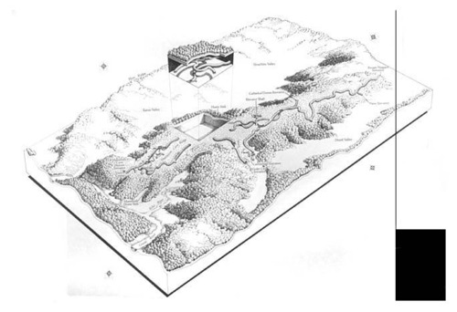
Oblique aerial view of Mammoth Cave National Park
Oblique aerial view of Mammoth Cave National Park
Features shown include Flint Ridge, Eaton Valley, historic entrance to Mammoth Cave, Mammoth Cave Visitor Center, Mammoth Dome Sink, Echo River, Green River, Mammoth Cave Ridge, Bruce Hollow, Jim Lee Ridge, Hunts Sink, Houchins Valley, Cathedral Domes entrance to cave, elevator shaft, Carmichael entrance to cave, Violet City entrance to cave, Doyel Valley, new entrance to cave, and Frozen Niagara entrance to cave
Abbr=EX
U.S. National Park Service
Art_Registration_No=EPD-0007; Reflective Art
Government owns art and all reproduction rights.
Public domain
Natural History, (HFC ArtTheme)
, Pen and ink with type overlay on pieced illustration board, (HFC ArtMedium)
, Pen and ink with type overlay on pieced illustration board, (HFC ArtMedium)
Image
Mammoth Cave National Park, Code: MACA
Mammoth Cave National Park, Kentucky
Latitude: 37.131649017334, Longitude: -86.1454315185547
Latitude: 37.131649017334, Longitude: -86.1454315185547
Image Management System : IMS 10588
20190904
01/01/1987 - 12/30/1987
Count:2/4; Graphic # MC-G-157
MC MM
Public Can View
Organization: Harpers Ferry Center
Address: Harpers Ferry Center, 67 Mather Place, Harpers Ferry, WV, 25425, 304-535-5050
Address: Harpers Ferry Center, 67 Mather Place, Harpers Ferry, WV, 25425, 304-535-5050
Friday, October 4, 2019 11:55:19 AM
Friday, October 4, 2019 11:55:19 AM
10588.jpg
jpg
48.3 kB
Museum