Select Item below to DOWNLOAD - Once item is selected, right click and choose 'save as'
The National Park Service is committed to making its electronic and information technologies accessible to individuals with disabilities.
If you require assistance or wish to report an issue related to the accessibility of any content on this website, please email NPGallery@nps.gov
If you require assistance or wish to report an issue related to the accessibility of any content on this website, please email NPGallery@nps.gov
b64387a1-3a42-42fc-96dc-90cb404769f4
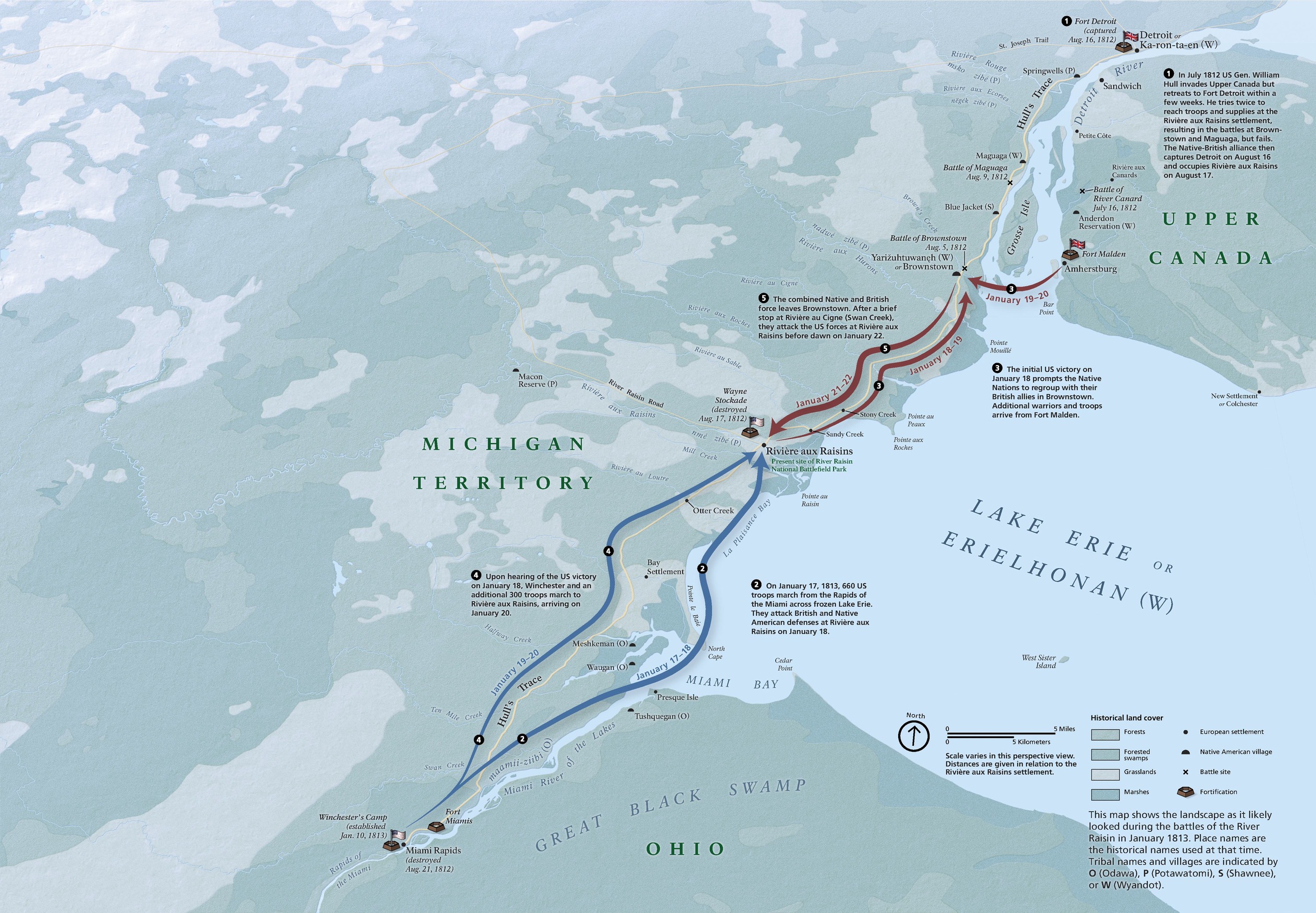
Campaign Map - River Raisin National Battlefield Park
Historic campaign map of River Raisin National Battlefield Park in Michigan. Snaking blue and maroon-red arrows show movements along the shore of a lake labeled, “Lake Erie or Erielhonan (W).”
Screen-viewable file; Adobe print production files can be downloaded from the Compressed zip Version link
Map Projection: 3D; Map Type: unassigned
U.S. National Park Service
The National Park Service maps are government produced and are in the public domain. Anyone may, without restriction under U.S. copyright laws: Reproduce the work in print or digital form; Create derivative works; Perform the work publicly; Display the work; Distribute copies or digitally transfer the work to the public by sale or other transfer of ownership, or by rental, lease, or lending. Please note, a user who modifies and/or republishes National Park Service maps are responsible for any problems encountered with the maps, due to their change or modification.
Public domain
Document
River Raisin National Battlefield Park, Code: RIRA
River Raisin National Battlefield Park, Monroe County, Michigan
Latitude: 41.9127998352051, Longitude: -83.3760986328125
Latitude: 41.9127998352051, Longitude: -83.3760986328125
2024-08-27
08/27/2024
Public Can View
Person: Harpers Ferry Center
Organization: US National Park Service
Address: Harpers Ferry Center, Harpers Ferry, WV
Email: HFC_Cartography@nps.gov
Organization: US National Park Service
Address: Harpers Ferry Center, Harpers Ferry, WV
Email: HFC_Cartography@nps.gov
Thursday, May 1, 2025 10:40:02 PM
Friday, September 26, 2025 11:37:16 PM
RIRAmap3.pdf
pdf
41.2 MB
Map