Select Item below to DOWNLOAD - Once item is selected, right click and choose 'save as'
a99fbf171d4940ee9a1ac7df651d8c2b
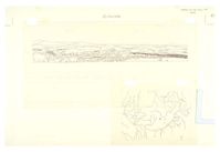
View and map of the Snake River drainage from Weiser, Idaho to Grand Teton National Park showing old and new lava fields.
View and map of the Snake River drainage from Weiser, Idaho to Grand Teton National Park showing old and new lava fields.
Abbr=WE
U.S. National Park Service
Reflective Art
Government owns art and all reproduction rights.
Public domain
Image
Craters of the Moon National Monument and Preserve, Code: CRMO
Craters of the Moon National Monument and Preserve, Idaho
Latitude: 43.0189094543457, Longitude: -113.626800537109
Latitude: 43.0189094543457, Longitude: -113.626800537109
Image Management System : IMS 03348
20190904
Exhibit 20
O 10
Public Can View
Organization: Harpers Ferry Center
Address: Harpers Ferry Center, 67 Mather Place, Harpers Ferry, WV, 25425, 304-535-5050
Address: Harpers Ferry Center, 67 Mather Place, Harpers Ferry, WV, 25425, 304-535-5050
Monday, October 7, 2019 3:01:29 PM
Monday, October 7, 2019 3:01:29 PM
03348.jpg
jpg
20.8 kB
Museum