Select Item below to DOWNLOAD - Once item is selected, right click and choose 'save as'
a6a350f07cec4b3b94b239e08d2da8f3
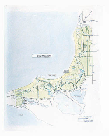
Map of Sleeping Bear Dunes National Lakeshore in Michigan.
Map of Sleeping Bear Dunes National Lakeshore in Michigan.
Illustration includes type overlay.; Abbr=EX
U.S. National Park Service
Project=Platte River Contact Station; Art_Registration_No=EX-0012 ; Reflective Art
Government owns art and all reproduction rights.
Public domain
Image
Sleeping Bear Dunes National Lakeshore, Code: SLBE
Sleeping Bear Dunes National Lakeshore, Michigan
Latitude: 45.1077919006348, Longitude: -86.0129470825195
Latitude: 45.1077919006348, Longitude: -86.0129470825195
Image Management System : IMS 07117
20190904
01/01/1994 - 12/30/1994
Image_Size=28" x 34-1/8; Count:41/41; Graphic # FE-G-0119 with type overlay
MC GG
Public Can View
Organization: Harpers Ferry Center
Address: Harpers Ferry Center, 67 Mather Place, Harpers Ferry, WV, 25425, 304-535-5050
Address: Harpers Ferry Center, 67 Mather Place, Harpers Ferry, WV, 25425, 304-535-5050
Monday, October 7, 2019 2:45:45 PM
Monday, October 7, 2019 2:45:45 PM
07117.jpg
jpg
26.0 kB
Museum