Select Item below to DOWNLOAD - Once item is selected, right click and choose 'save as'
a0f30c3288ce4828a182d20049b092da
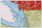
Map showing the 49th parallel as the dividing line between the United States territory to the south and the territory of Great Britain to the north. Vancouver's and San Juan Islands shown in white.
Map showing the 49th parallel as the dividing line between the United States territory to the south and the territory of Great Britain to the north. Vancouver's and San Juan Islands shown in white.
Abbr=AVA
U.S. National Park Service
Project=The Pig War ; Reflective Art
Government owns art and all reproduction rights.
Public domain
Image
San Juan Island National Historical Park, Code: SAJH
San Juan Island National Historical Park, San Juan County, Washington
Latitude: 48.4618988037109, Longitude: -123.005996704102
Latitude: 48.4618988037109, Longitude: -123.005996704102
Image Management System : IMS 01545
20190904
01/01/1978 - 12/30/1978
Image_Size=W: 14" x H: 10"; Metric_Size=W: 35.53CM X H: 25.38CM; Slide Show #253; "The Pig War", AVA Project #35; Plate 4
C6
Public Can View
Organization: Harpers Ferry Center
Address: Harpers Ferry Center, 67 Mather Place, Harpers Ferry, WV, 25425, 304-535-5050
Address: Harpers Ferry Center, 67 Mather Place, Harpers Ferry, WV, 25425, 304-535-5050
Monday, October 7, 2019 3:04:42 PM
Monday, October 7, 2019 3:04:42 PM
01545.JPG
jpg
87.2 kB
Museum