Select Item below to DOWNLOAD - Once item is selected, right click and choose 'save as'
9db10502d74641f8a9d34d0618440172
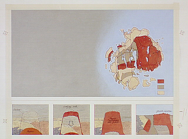
Split panel with a geologic map (top) showing distribution of granites on Mount Desert Island.
Split panel with a geologic map (top) showing distribution of granites on Mount Desert Island.
Four-part diagram (bottom) illustrating the formation of the island's coarse grained granites, based on the diagrams in Carleton A. Chapman, "The Geology of Acadia National Park," page 18. The four-part portion of this illustration has been revised with new art.
The four-part diagram portion of this illustration has been revised as new art.; Abbr=WE
U.S. National Park Service
Reflective Art
Government owns art and all reproduction rights.
Public domain
Acrylic on illustration board, (HFC ArtMedium)
Image
Acadia National Park, Code: ACAD
Acadia National Park, Maine
Latitude: 44.3593788146973, Longitude: -68.2397308349609
Latitude: 44.3593788146973, Longitude: -68.2397308349609
Image Management System : IMS 00089
20190904
01/01/1981 - 12/30/1981
Image_Size=W: 20 3/4" x H: 16 1/4"; Metric_Size=W: 52.66CM X H: 41.24CM; Count: 17/23; Exhibit 15/Graphic # 15-9 & 15-10
Q2
Public Can View
Organization: Harpers Ferry Center
Address: Harpers Ferry Center, 67 Mather Place, Harpers Ferry, WV, 25425, 304-535-5050
Address: Harpers Ferry Center, 67 Mather Place, Harpers Ferry, WV, 25425, 304-535-5050
Thursday, October 3, 2019 6:58:26 PM
Thursday, October 3, 2019 6:58:26 PM
00089.JPG
jpg
66.4 kB
Museum