Select Item below to DOWNLOAD - Once item is selected, right click and choose 'save as'
6a07195f487e46b0b249df007905ca65
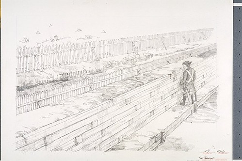
Conceptual illustration viewed from inside the town of Frederica showing a section of the completed town wall and moat earthworks in 1742.
Conceptual illustration viewed from inside the town of Frederica showing a section of the completed town wall and moat earthworks in 1742.
Dennis Simon's illustration based on a drawing in Albert Manucy's "Town Model Specifications."; Abbr=WE
U.S. National Park Service
Reflective Art
Government owns art and all reproduction rights.
Public domain
Graphite on gessoed illustration board, (HFC ArtMedium)
Image
Fort Frederica National Monument, Code: FOFR
Fort Frederica National Monument, Glynn County, Georgia
Latitude: 31.2236003875732, Longitude: -81.3898010253906
Latitude: 31.2236003875732, Longitude: -81.3898010253906
Image Management System : IMS 04550
20190904
01/01/1986 - 12/30/1986
Image_Size=17" x 11"; Exhibit 29/Graphic # 29-6
I 13
Public Can View
Organization: Harpers Ferry Center
Address: Harpers Ferry Center, 67 Mather Place, Harpers Ferry, WV, 25425, 304-535-5050
Address: Harpers Ferry Center, 67 Mather Place, Harpers Ferry, WV, 25425, 304-535-5050
Thursday, October 3, 2019 4:53:54 PM
Thursday, October 3, 2019 4:53:54 PM
04550.JPG
jpg
64.5 kB
Museum