Select Item below to DOWNLOAD - Once item is selected, right click and choose 'save as'
4f4c22182b6c4361b4321c059510e04e
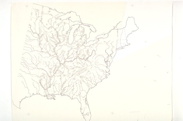
Map depicts mounds of the Eastern woodlands showing: general distribution of mounds; name and location of major mound sites; and major lakes, rivers, and state lines.
Map depicts mounds of the Eastern woodlands showing: general distribution of mounds; name and location of major mound sites; and major lakes, rivers, and state lines.
Abbr=EX
U.S. National Park Service
Project=Visitor Center; Art_Registration_No=EPD-0004 ; Reflective Art
Government owns art and all reproduction rights.
Public domain
Geography, (HFC ArtTheme)
Image
Effigy Mounds National Monument, Code: EFMO
Effigy Mounds National Monument, Iowa
Latitude: 43.0914611816406, Longitude: -91.2077713012695
Latitude: 43.0914611816406, Longitude: -91.2077713012695
Image Management System : IMS 06318
20190904
01/01/1988 - 12/30/1988
Count:18/31; Graphic # EM-G-137
J8
Public Can View
Organization: Harpers Ferry Center
Address: Harpers Ferry Center, 67 Mather Place, Harpers Ferry, WV, 25425, 304-535-5050
Address: Harpers Ferry Center, 67 Mather Place, Harpers Ferry, WV, 25425, 304-535-5050
Monday, October 7, 2019 2:46:25 PM
Monday, October 7, 2019 2:46:25 PM
06318.JPG
jpg
38.2 kB
Museum