Select Item below to DOWNLOAD - Once item is selected, right click and choose 'save as'
285bd021356c41668352cbc51ac55036
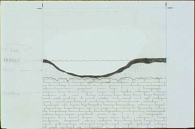
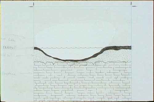
Cutaway diagram showing how hurricane winds and storm tides carry salty mud from the Florida Bay to West Lake
Cutaway diagram showing how hurricane winds and storm tides carry salty mud from the Florida Bay to West Lake
Mud deposition increases the elevation and the amount of salt in the soil - two factors that dictate which plants will grow here Diagram shows (top to bottom) West Lake, mud, old soil, and limestone
Abbr=WE
U.S. National Park Service
Project=Mangrove Trail; Reflective Art
Government owns art and all reproduction rights.
Public domain
Image
Everglades National Park, Code: EVER
Everglades National Park, Florida
Latitude: 25.2717704772949, Longitude: -80.953498840332
Latitude: 25.2717704772949, Longitude: -80.953498840332
Image Management System : IMS 00472
20190904
01/01/1980 - 12/30/1980
Image_Size=W: 9 5/8" x H: 10 15/16"; Metric_Size=W: 22.84CM X H: 25.38CM; Exhibit 2
E2
Public Can View
Organization: Harpers Ferry Center
Address: Harpers Ferry Center, 67 Mather Place, Harpers Ferry, WV, 25425, 304-535-5050
Address: Harpers Ferry Center, 67 Mather Place, Harpers Ferry, WV, 25425, 304-535-5050
Friday, October 4, 2019 2:56:57 PM
Friday, October 4, 2019 2:56:57 PM
00472.JPG
jpg
50.1 kB
Museum