Select Item below to DOWNLOAD - Once item is selected, right click and choose 'save as'
aaf6e251-d95e-452c-bddd-710a9f3b1996
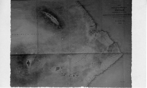
Topographical Map of Eastern Hawaiʻi
A black and white image of Charles Wilkes' topographical map of Hawaiʻi island. It is a map of the eastern portion of the island. Important towns represented by black dots are labeled along the coastline extending from Hilo to Kupapaʻu. It also has roughly drawn lines indicating roads/trails that go out from Hilo, along the coast, and around Mauna Loa and Kīlauea volcanoes. There are circles and outlines of the various craters of Kīlauea and Mauna Loa. They are labeled. Around Mauna Loa crater there are a series of elevation lines going out from the crater to indicate elevation changes in the landscape. There is a title for the map in the top right corner of the image. It reads, "MAP Part of the Island of Hawaii Sandwich Islands Shewing The Craters and Eru of May and June 1840 by the U. S. Ex. Ex. 1841." On the bottom right corner there is a scale for miles.
A copy of Charles Wilkes' topographical map of Hawaiʻi island showing the eastern side of the island.
Hawaiʻi Volcanoes National Park Museum and Archives
NO COPYRIGHT - UNITED STATES: The organization that has made the Item available believes that the Item is in the Public Domain under the laws of the United States, but a determination was not made as to its copyright status under the copyright laws of other countries. The Item may not be in the Public Domain under the laws of other countries. Please refer to the organization that has made the Item available for more information. Reference http://rightsstatements.org/vocab/NoC-US/1.0/
Wilkes Charles - US Navy
Restrictions apply on use and/or reproduction:NO COPYRIGHT. For more information about this digital asset, contact Hawaii Volcanoes National Park, Museum Program, at havo_archive_museum@nps.gov
Interpretation, (Hawaii Volcanoes Historic Image Collection Theme)
, Cultural Resources, (Hawaii Volcanoes Historic Image Collection Theme)
, Cultural Resources, (Hawaii Volcanoes Historic Image Collection Theme)
Image
Hawaii Volcanoes National Park, Code: HAVO
Hawaii Volcanoes National Park, Hawaii County, Hawaii
Latitude: 19.3775997161865, Longitude: -155.602996826172
Latitude: 19.3775997161865, Longitude: -155.602996826172
NPS Museum Catalog Number : HAVO 17707
Circa 1841
01/01/1860 - 12/30/1910
Public Can View
Person: Museum Staff
Organization: Hawaiʻi Volcanoes National Park
Email: havo_archive_museum@nps.gov
Organization: Hawaiʻi Volcanoes National Park
Email: havo_archive_museum@nps.gov
Wednesday, January 10, 2024 6:05:10 PM
Thursday, February 1, 2024 6:29:03 PM
HAVO17707_B002f013_0005.tif
tif
10.6 MB
Historic