Select Item below to DOWNLOAD - Once item is selected, right click and choose 'save as'
0dca45f2-8ab5-4ea1-bc84-b367a9e68dc9
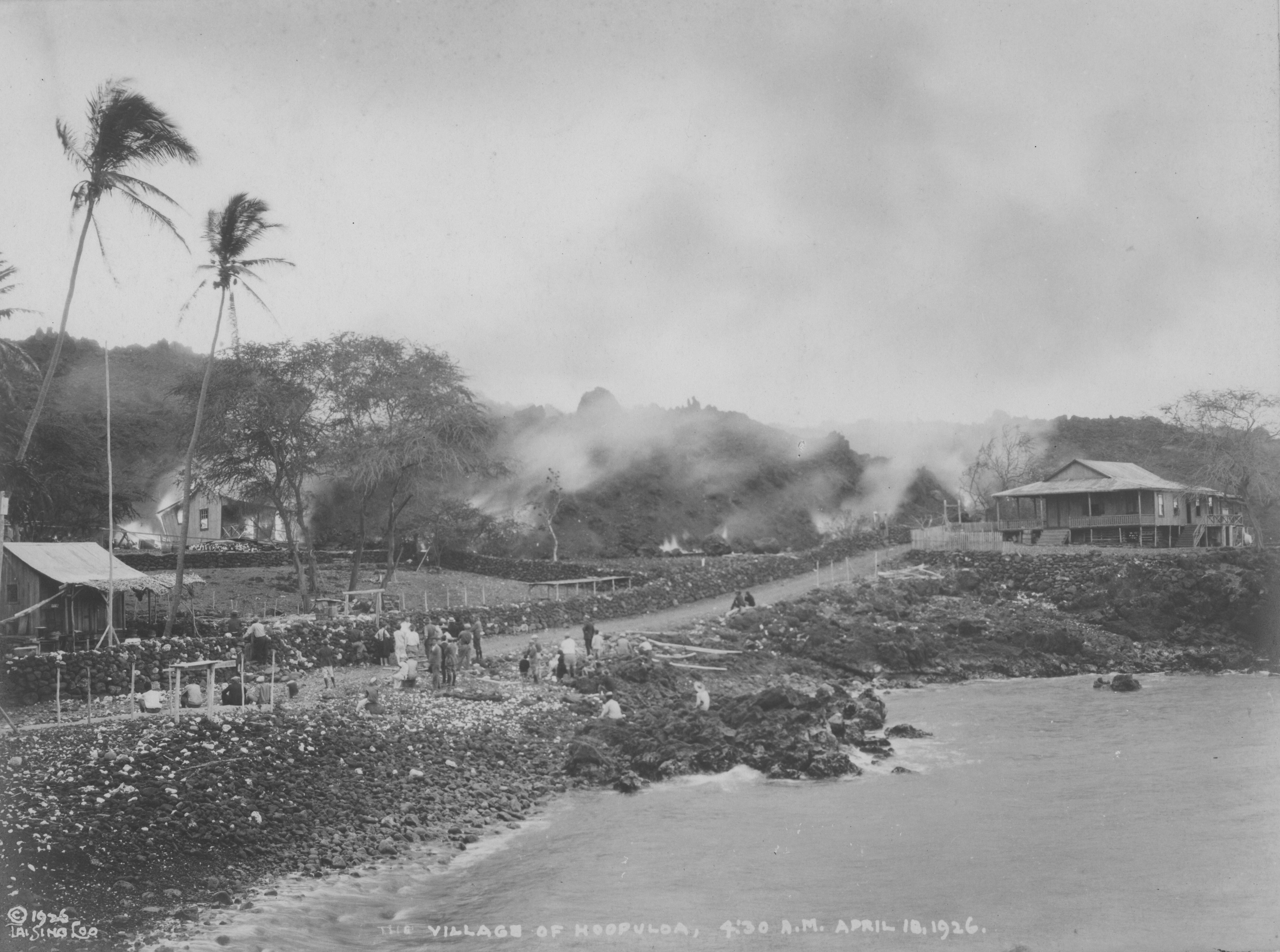
Mauna Loa Eruption Causing Destruction at Ho‘ōpūloa Village
Black and white photograph of a village near the ocean. The water is present on the bottom right of the photograph near the sloped, rocky shoreline to the left. Above the water level, a dirt road runs from the left side of the image towards the right. A large house sits furthest above the water on top of a rocky hill on the right side. Many people sit and stand along the road with their backs to the camera, looking towards the elevated land to the left of the road. The elevated land emits many clouds of smoke that turn dark when rising into the sky, drifting towards the right. At the base of the elevation, on the left side, a small house is ablaze. A few tall trees are present throughout the village. Handwriting along the bottom of the photograph reads, “The Village of Hoopuloa, 4:30 A.M. April 18, 1926.” “Copyright 1926 Tai Sing Loo” is written in the bottom left corner.
Mauna Loa eruption of ‘a‘ā lava flow causing destruction at Ho‘ōpūloa village, captured by Tai Sing Loo at 4:30AM on April 18, 1926.
Hawaiʻi Volcanoes National Park Museum and Archives
NO COPYRIGHT - UNITED STATES: The organization that has made the Item available believes that the Item is in the Public Domain under the laws of the United States, but a determination was not made as to its copyright status under the copyright laws of other countries. The Item may not be in the Public Domain under the laws of other countries. Please refer to the organization that has made the Item available for more information. Reference http://rightsstatements.org/vocab/NoC-US/1.0/
Loo, Tai Sing - US Navy
Restrictions apply on use and/or reproduction:NO COPYRIGHT. For more information about this digital asset, contact Hawaii Volcanoes National Park, Museum Program, at havo_archive_museum@nps.gov
Mauna Loa Eruptions (1903-1933), (Mauna Loa Eruptions)
Image
Hawaii Volcanoes National Park, Code: HAVO
Ho‘ōpūloa ; Hawai'i
Latitude: 19.2006, Longitude: -155.9069
Hawaii Volcanoes National Park, Hawaii County, Hawaii
Latitude: 19.3775997161865, Longitude: -155.602996826172
Latitude: 19.2006, Longitude: -155.9069
Hawaii Volcanoes National Park, Hawaii County, Hawaii
Latitude: 19.3775997161865, Longitude: -155.602996826172
NPS Museum Catalog Number : HAVO 20724
1926/04/18
01/01/1911 - 12/30/1939
Public Can View
Organization: Hawaiʻi Volcanoes NP
Position: Curator
Address: 1 Crater Rim Drive, Hawaii National Park
Email: havo_archive_museum@nps.gov
Position: Curator
Address: 1 Crater Rim Drive, Hawaii National Park
Email: havo_archive_museum@nps.gov
Wednesday, April 17, 2024 3:52:22 PM
Wednesday, April 17, 2024 3:52:22 PM
HAVO20724_B005f001_0016.tif
tif
31.4 MB
Historic